Bolivia
I traveled to many adventurous places in southwestern Bolivia for four weeks in November and December 2025. Note: Bolivia is a large country offering a myriad of experiences. My trip is a fraction of what's possible so make sure to do additional research on your own.
Table of Contents:
The Basics
Salar de Uyuni
Eduardo Avaroa Andean Fauna National Reserve
La Paz: Centro Historico, Death Road, Valle de la Animas & the Teleferico
The Basics
Border Entry: Aside from your passport, there is a good chance that you’ll need a Visa, even if you’re American. However, the rules seem to change frequently so do your own homework. Visas can be obtained on arrival (approx. $160 USD) or in advance, valid for 30 days. It’s a bit of an inconvenience compared to other countries but the upside is fewer tourists to deal with.
Vaccines: There is a 50% chance that border control will ask for your vaccine card. I believe the only required vaccine is Yellow Fever, specifically for the more tropical areas of the country.
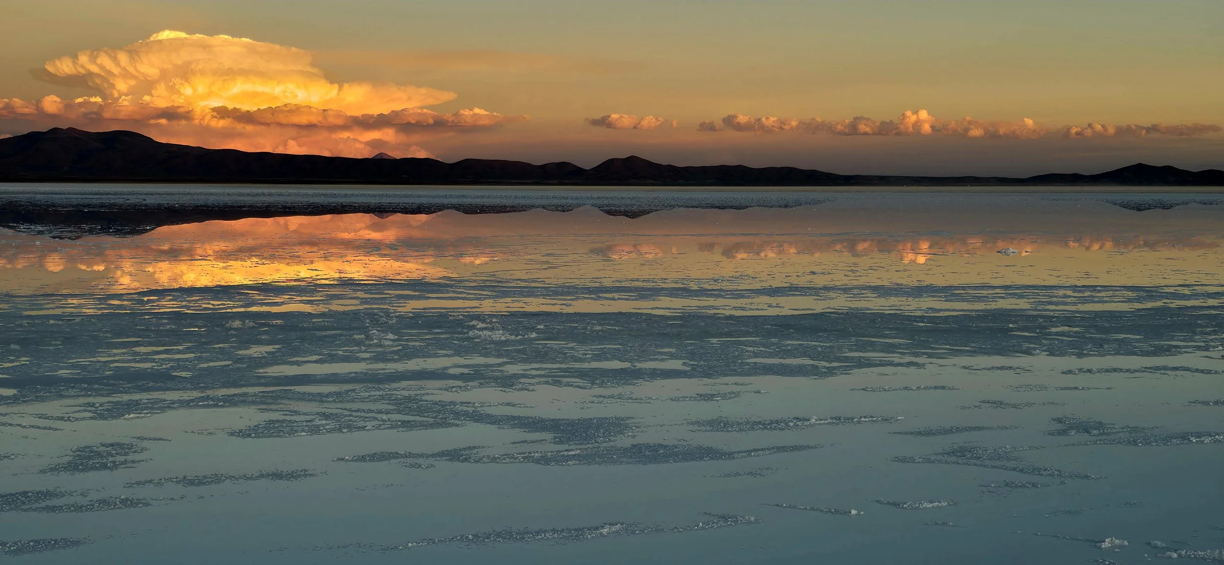
Best Time of Year to Visit: The best time to visit Bolivia is during the dry season from May to October, when skies are clear, days are longest and roads are accessible, particularly for visiting the Salar de Uyuni. April and October/November are excellent shoulder months, offering pleasant weather with fewer crowds. The rainy season (January–March) is best for seeing the salt flat "mirror effect." For me, the weather was perfect during late November–December, with mostly sunny skies and cool temperatures. The only part that could've been better was the "mirror effect" in Salar de Uyuni.
Visit Duration: Assuming you’re in full vacation mode and not working, I recommend staying for 2-3 weeks. Similar to other mountainous regions, the weather can be very unpredictable so it’s smart to allow a few extra days in case you need to reschedule an activity.
Weather & Altitude: Temperatures can vary greatly by region, but the capital, La Paz averaged around 75- 80 degrees in Nov and Dec. It can get much colder in the mountains, even during summer months, so bring clothing for all seasons to be safe. Altitude sickness is a real concern in Bolivia, even for those who have never been impacted before like myself. La Paz, Bolivia, is the world's highest administrative capital, with an average altitude between approximately 11,942 and 11,975 feet above sea level, and it only gets higher from there! To put this in perspective, average Colorado mountain ranges generally sit around 9,000 feet. To prepare for the altitude, allow 2-3 days for acclimatization. Upon arrival, drink 3-4 liters of water daily, eat high-carb meals and avoid alcohol. Use medication like Acetazolamide and local remedies like coca tea to alleviate the altitude sickness. The symptoms can vary greatly by individual, but one thing is for sure: you will most likely be humbled. For me, my HIIT workouts were nearly impossible and I often had to take short breaks just walking through the streets of La Paz. Frequent dehydration also made it difficult to use the bathroom and sleep at night. Many others suffer from nausea, vomiting and frequent lightheadedness. Even after a few weeks, I never truly got accustomed to the altitude, but it wouldn't stop me from going back!
Accommodations: La Paz and Salar de Uyuni served as my home bases for most of the trip. However, you might need to book a few one-off hotels in other areas, but tour companies typically handle those bookings.
La Paz: The two best areas to stay in La Paz are Centro Histórico, highly recommended for first-time visitors prioritizing walking access to museums and tourist sites, and Zona Sur for a modern, warmer, and more upscale experience. I stayed in Zona Sur because it was important for me to be in a safe area with healthy restaurants, grocery stores and gyms nearby (if not in my hotel) and the altitude is roughly 1,500 feet lower. Although the Centro Historico area is more fascinating, finding healthy options and gyms is nearly impossible unless you stay at the Illampu Art Boutique Hotel and even then, options are extremely limited. Although Zona Sur has many upscale hotels, I stayed at Casa Grande Hotel because it receives some of the best reviews. Additionally, it featured an amazing gym, an awesome rooftop cocktail bar, and an upscale on-site restaurant. Both areas felt very safe during the day, but I'd be more cautious in Centro Historico at night.
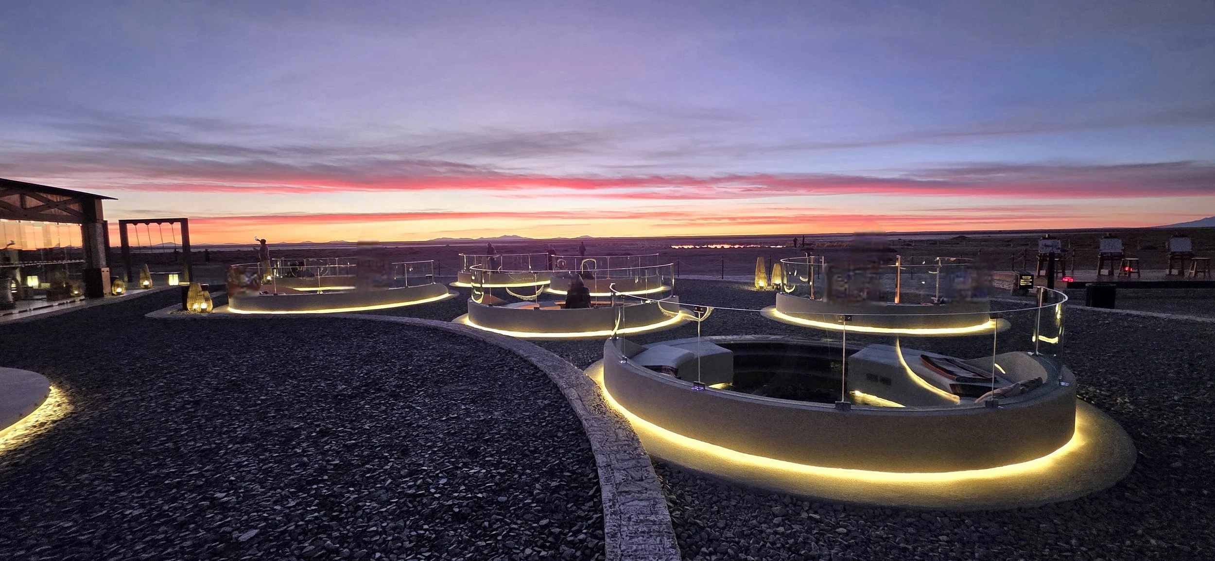
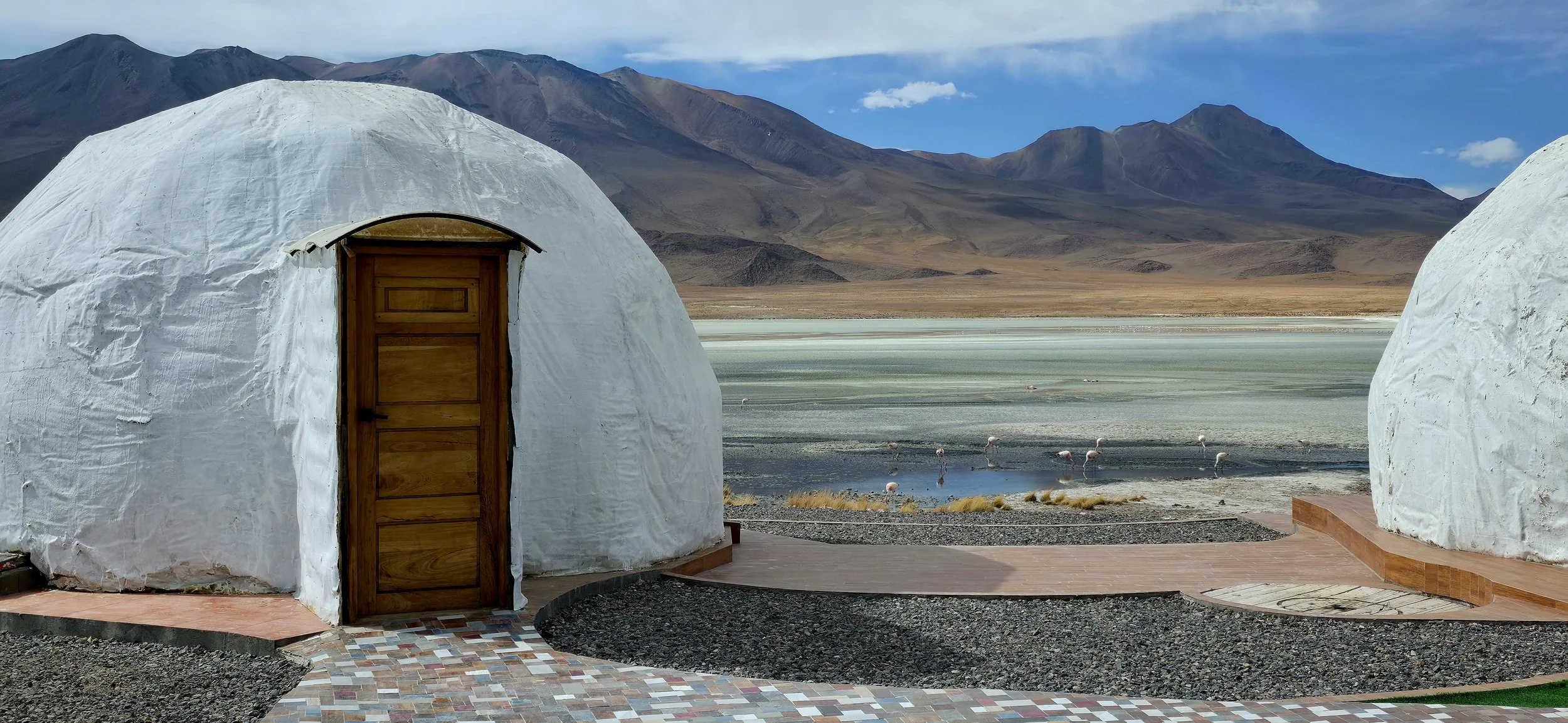
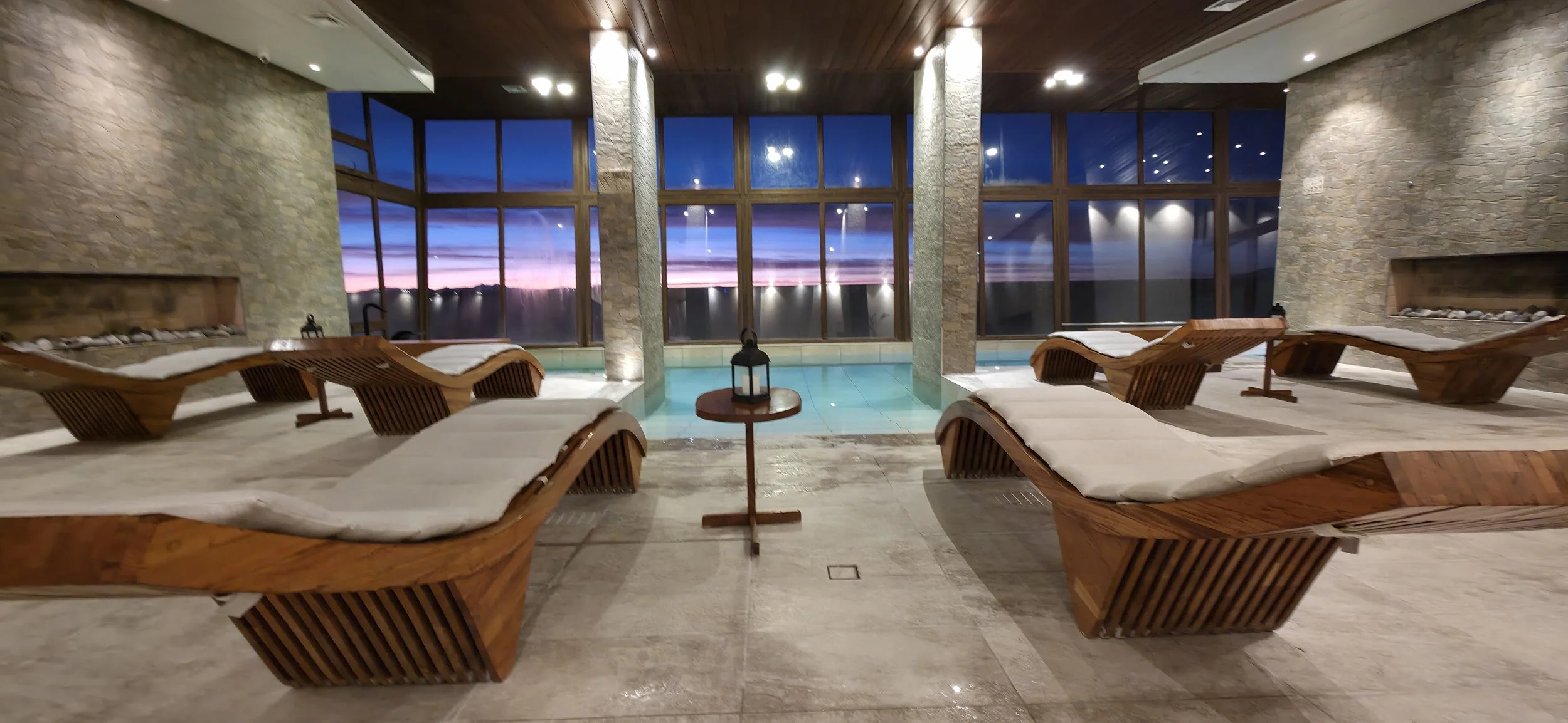
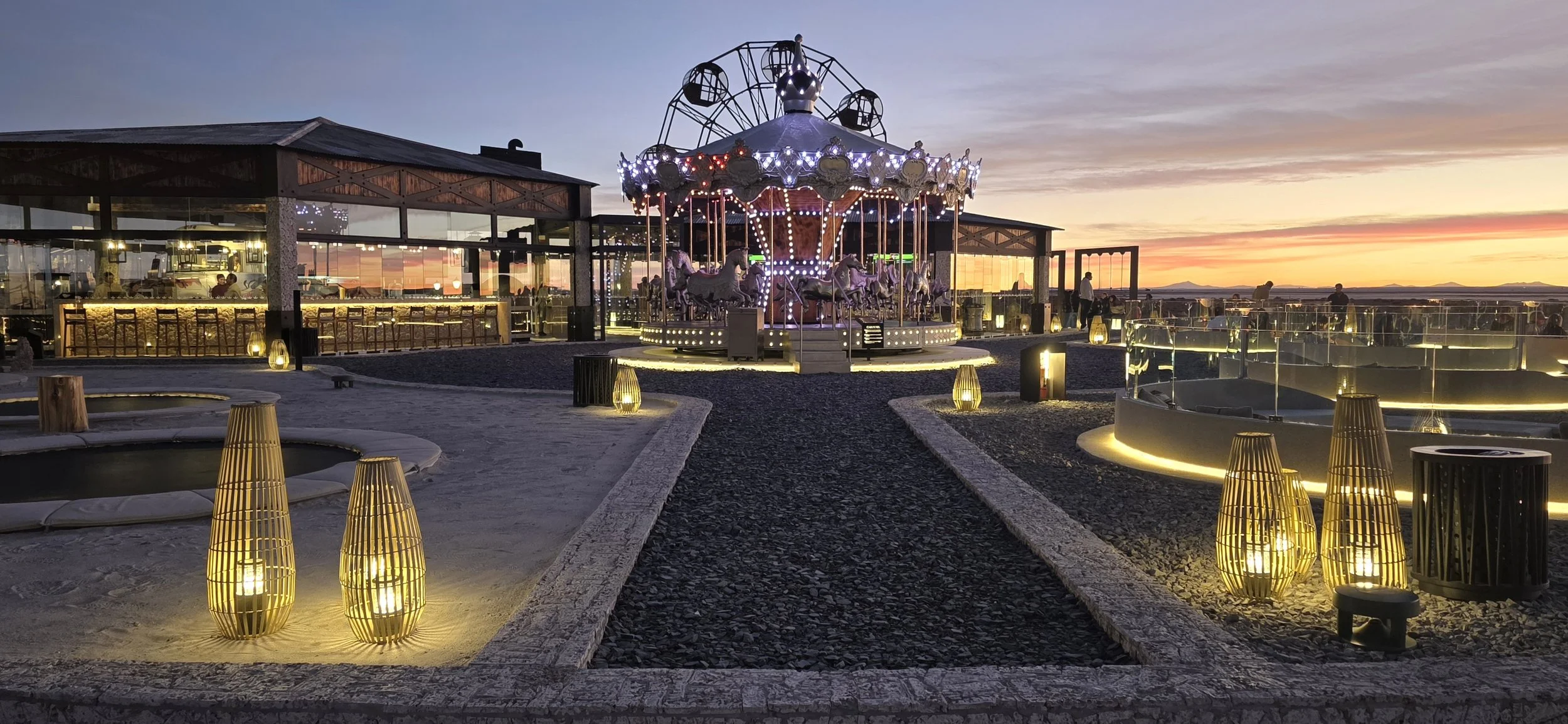
Salar de Uyuni: The most popular hotel by far is Hotel Palacio de Sal where I stayed for most of my visit. I recommend booking extremely far in advance or you'll likely miss out. Palacio de Sal is located about 30 minutes from the city of Uyuni, right at the border of the salt flats, offering an unbeatable location. It's a magical spot and the world's first hotel built entirely from salt blocks, offering a unique and luxurious experience featuring a salt-water spa, igloo-shaped rooms, a regional restaurant and stunning views of the vast salt flats. I couldn't stop taking pictures of the outdoor playground (it's the photo above) because it felt straight out of a movie. If the Hotel Palacio is unavailable, my second recommendation is Hotel Luna Salada which is a short drive from Palacio. Although not as dramatic as Palacio, it offered a larger and more healthy breakfast buffet. Neither hotel has a gym, but the Palacio offers bike rentals.
Costs: Bolivia is widely considered one of the cheapest countries in South America, offering exceptional value for budget-conscious travelers. What's super cool is that you can ride the teleférico (cable cars) all day for just a few dollars. However, costs increase significantly in areas like Salar de Uyuni and other tourism hot spots.
Transportation: I do not recommend renting a car in Bolivia for the following reasons: 1) La Paz is chaotic and has poor signage. 2) Rideshare apps and taxis are cheap, safe and abundant. 3) All tours from La Paz and Salar de Uyuni include private drivers. Additionally, the Teleférico (cable car system) is a major form of transportation that is easy to figure out and navigate. More on the Teleferico follows below.
Rideshare Apps: A few rideshare apps operate in La Paz, but Uber is by far the easiest. Taxis are generally safe if you use official "radio taxis" rather than hailing random cars on the street. Uber does not operate in Salar de Uyuni and taxis are the main and safe form of transportation.
Groceries: Finding healthy grocery stores similar to Whole Foods in La Paz is nearly impossible. HiperMaxi is considered the higher-end grocery store in Zona Sur and is roughly a 5 minute walk from the Casa Grande Hotel. Another option is to eat at a few healthy restaurants in the trendy Calacoto zone where you'll find places similar to Sweet Greens and Carrot Express in the United States. I ate at these restaurants for dinner and used HiperMaxi to buy my fruits and snacks. In Salar de Uyuni, dining options are limited to hotels unless you stay in downtown Uyuni which I don't recommend.
Fitness Centers: There are a few nice gyms in Zona Sur, but nothing spectacular. Additionally, finding stores that sell weights and other exercise equipment is difficult. I strongly recommend staying at an upscale hotel like Casa Grande, which has more state-of-the-art equipment. Zona Sur is also much more suitable for running than Centro Historico. Although the hotels at Salar de Uyuni are super nice, most lack gyms.
Wi-Fi: Connections are solid in most of La Paz and typically very dependable in the city of Uyuni. However, you will likely lose Wi-Fi shortly after leaving La Paz, and especially when leaving Uyuni for the salt flats and surrounding national parks.
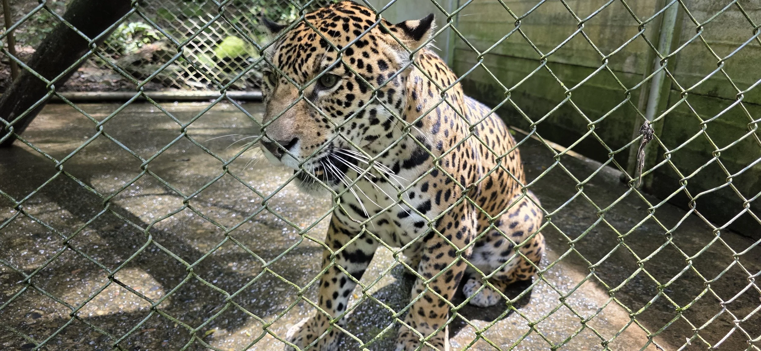
Wildlife: You're most likely not going to see any cool wildlife in La Paz. On the other hand, you will have many exciting opportunities to see llamas, wild vicunas, alpacas, flamingos, condors, viscachas, and much more in the National Reserves. The only predators are the elusive Andean cat and pumas, however, both are extremely rare to see since they stick to rocky, remote areas.
Random Recommendations: As I say in most blogs, always try to book anything that can be impacted by weather earlier in the trip. That way, you can always reschedule the activity to another day if needed. Similarly, have backup options ready for those activities that might get canceled.
The rest of the blog is separated into three sections: La Paz, Salar de Uyuni and the Eduardo Avaroa Andean Fauna National Reserve. I chose to visit Salar de Uyuni and the National Reserve before La Paz because I love nature and wanted as much time as possible there. However, many people might find it easier to stay in La Paz for the first few days to get accustomed to the altitude, as it only gets higher in the other areas.
Salar de Uyuni
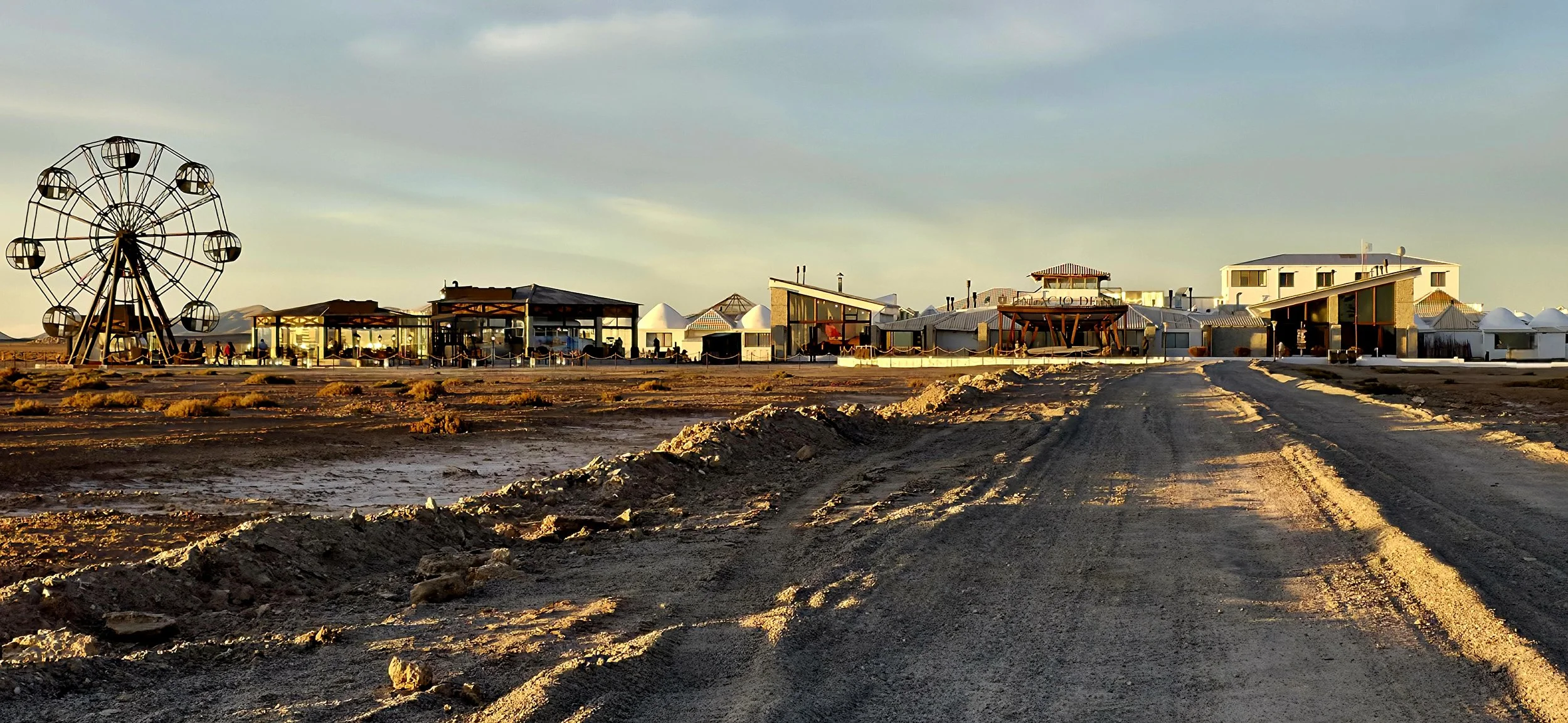
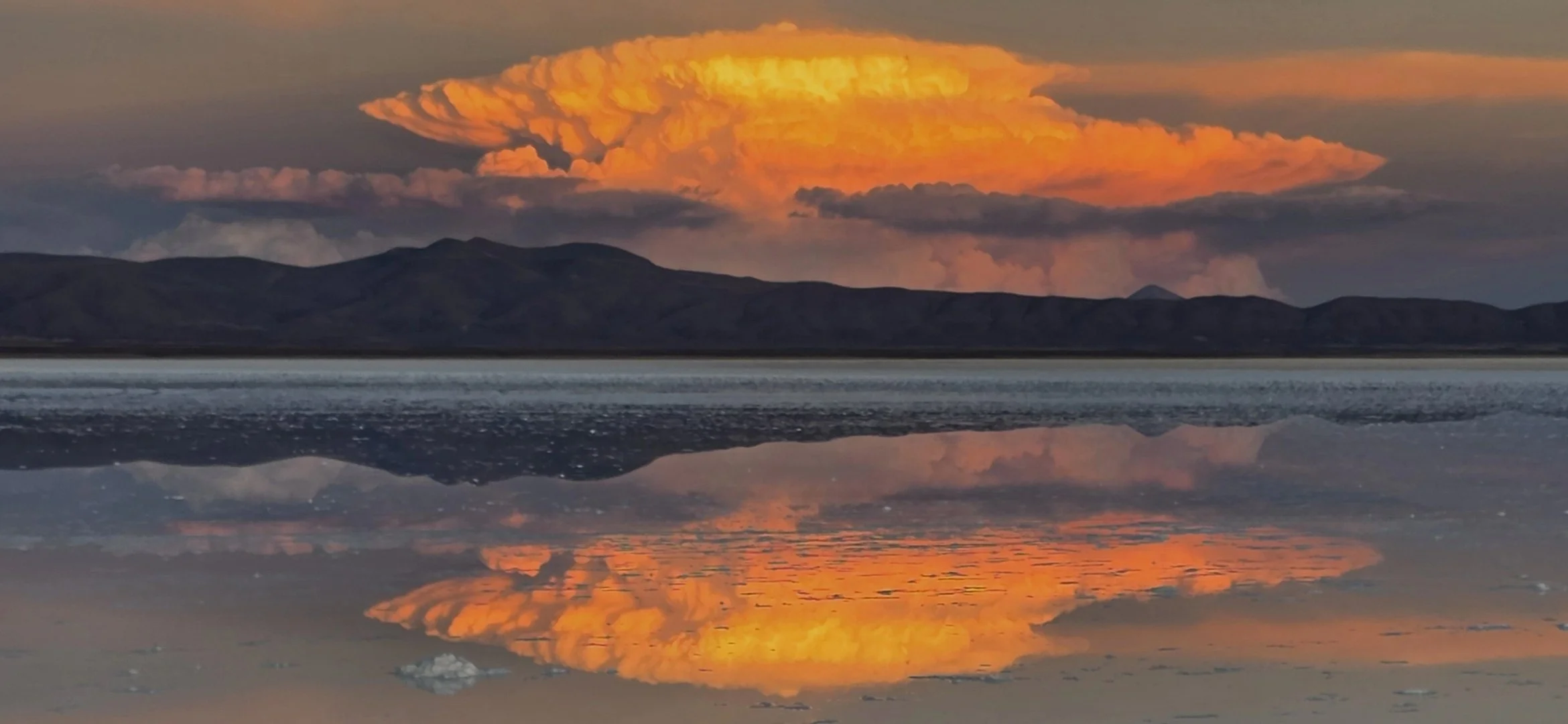
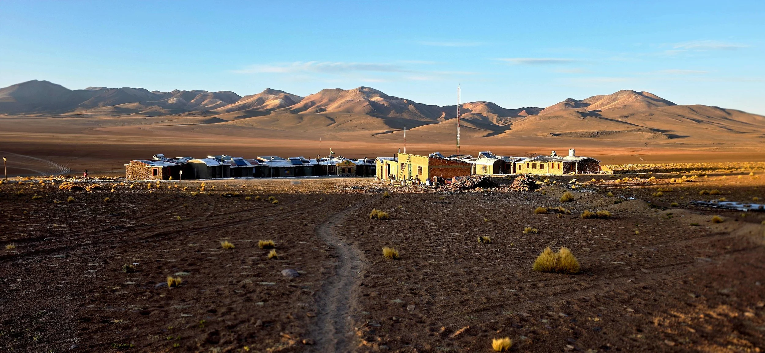
Since no direct flights exist from the United States to Uyuni, you will most likely have a short one-hour connecting flight (via BoA) from La Paz or Santa Cruz. From the Uyuni airport, your hotel or tour company's shuttle will likely pick you up, but taxis are typically readily available and safe. As mentioned in the Accommodations section, Hotel Palacio de Sal offers the most luxurious and unique hotel experience. Your tour company should provide hotel options and book on your behalf, but Palacio often sells out if you don't book 6 months in advance. This photo was taken approximately 100 yards from the entrance during sunset after most of the hotel staff had left in their cars. The large sunset photo at the top of this blog captures many of the hotel's amenities upclose. Although the hotel has kids' rides, the vast majority of guests are adults.
I booked a three-day tour via Visit South America because it was private and customizable--I love starting super early to avoid any potential crowds and capture better photos. You'll typically have two companions: the driver and the actual guide. They get paid very well and don't rely on tips, but I gave each of them $100 USD because it was a spectacular experience. Be advised that their English skills are subpar to say the least, so it was a great opportunity to practice my Spanish!
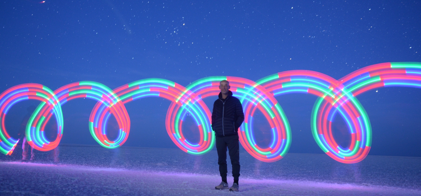
My first day's stargazing excursion was an extra "add-on cost," but since I may not ever return, I felt it was worth a splurge. The tour started at 4am and the drive goes deep into the salt flat to avoid any man-made light. Be prepared for very cold weather; I couldn't stay outside the truck for more than 10 minutes at a time. Honestly, I didn't have very high expectations but the quantity of visible stars, constellations and planets blew me away and I couldn't stop staring at the Milky Way. My guides took this photo using special props and lighting. They will even create a time lapse video of the sunrise upon request. After a few hours on the flat, the guides will drop you off at your hotel to relax for a few hours before the next trek begins.
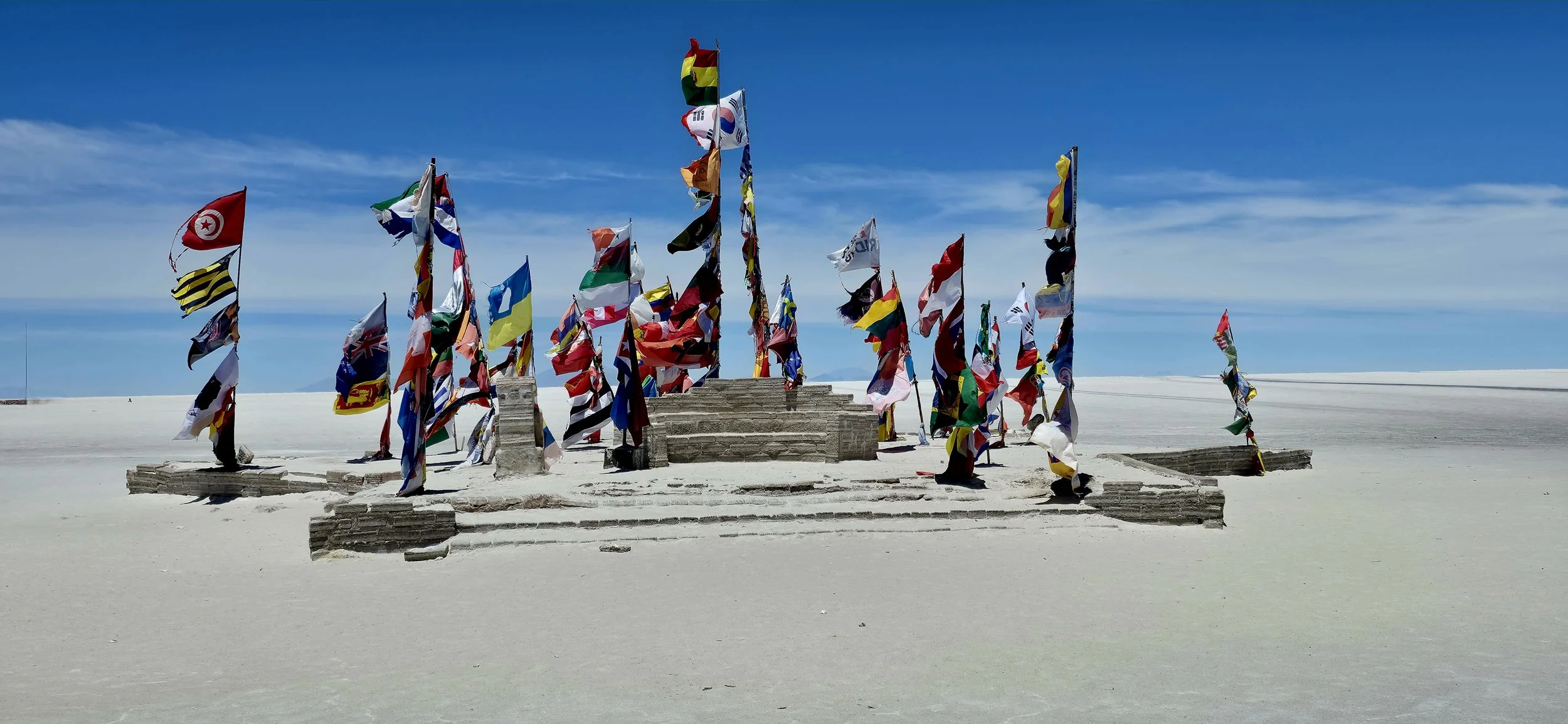
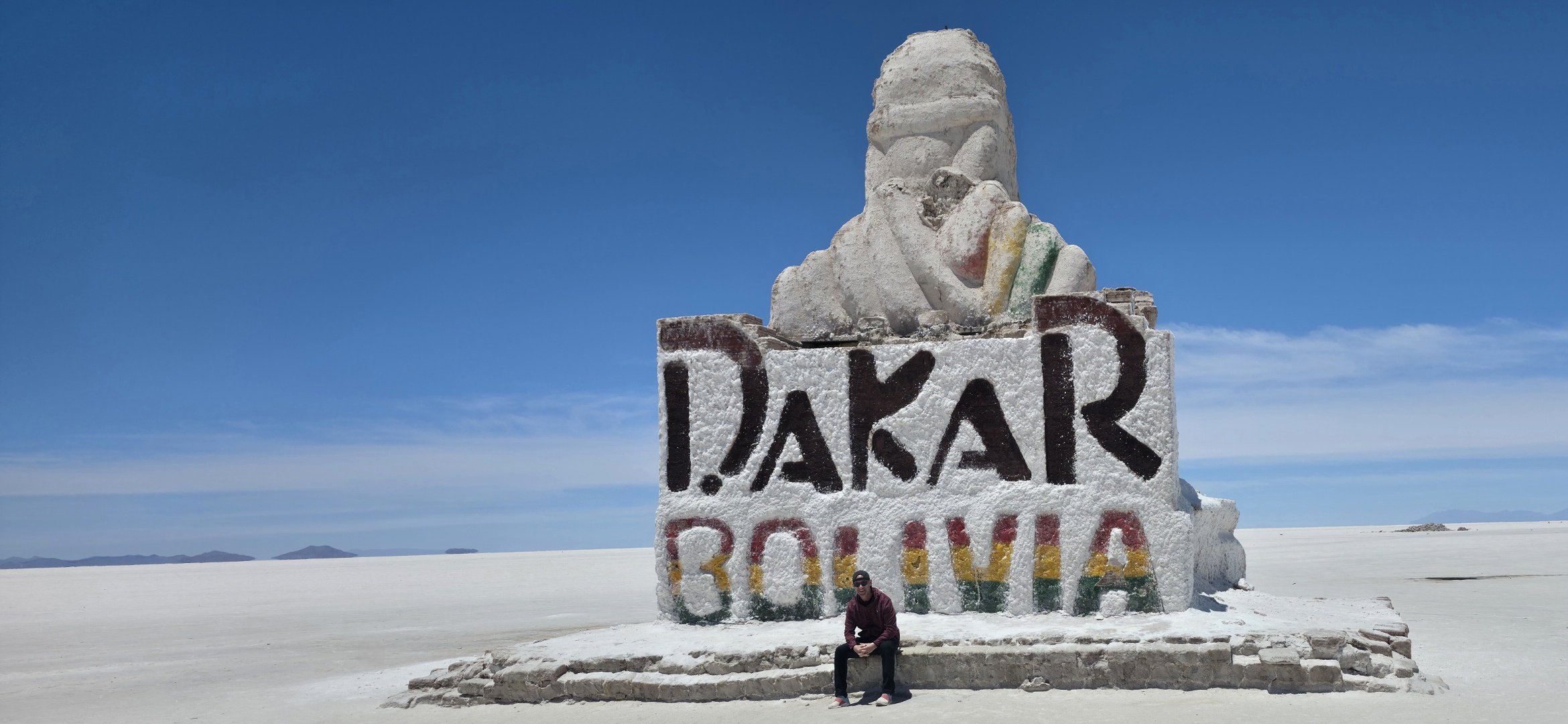
Later that same morning, we started a long road trip to the salt flats. Our first stop was the Dakar Monument and the photo of the flags there is iconic. However, this area can be slightly crowded with tourists, so grab a few pictures and move on to stay ahead of the crowds.
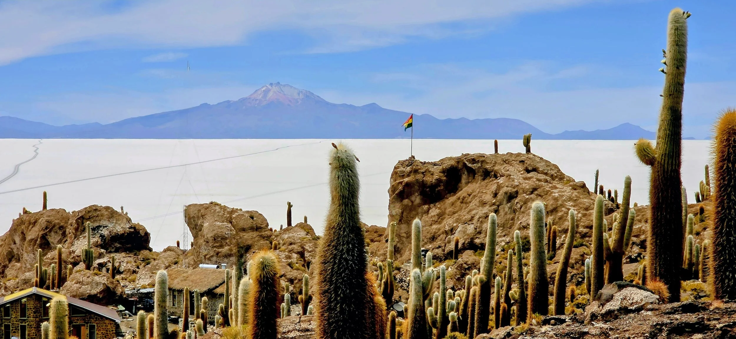
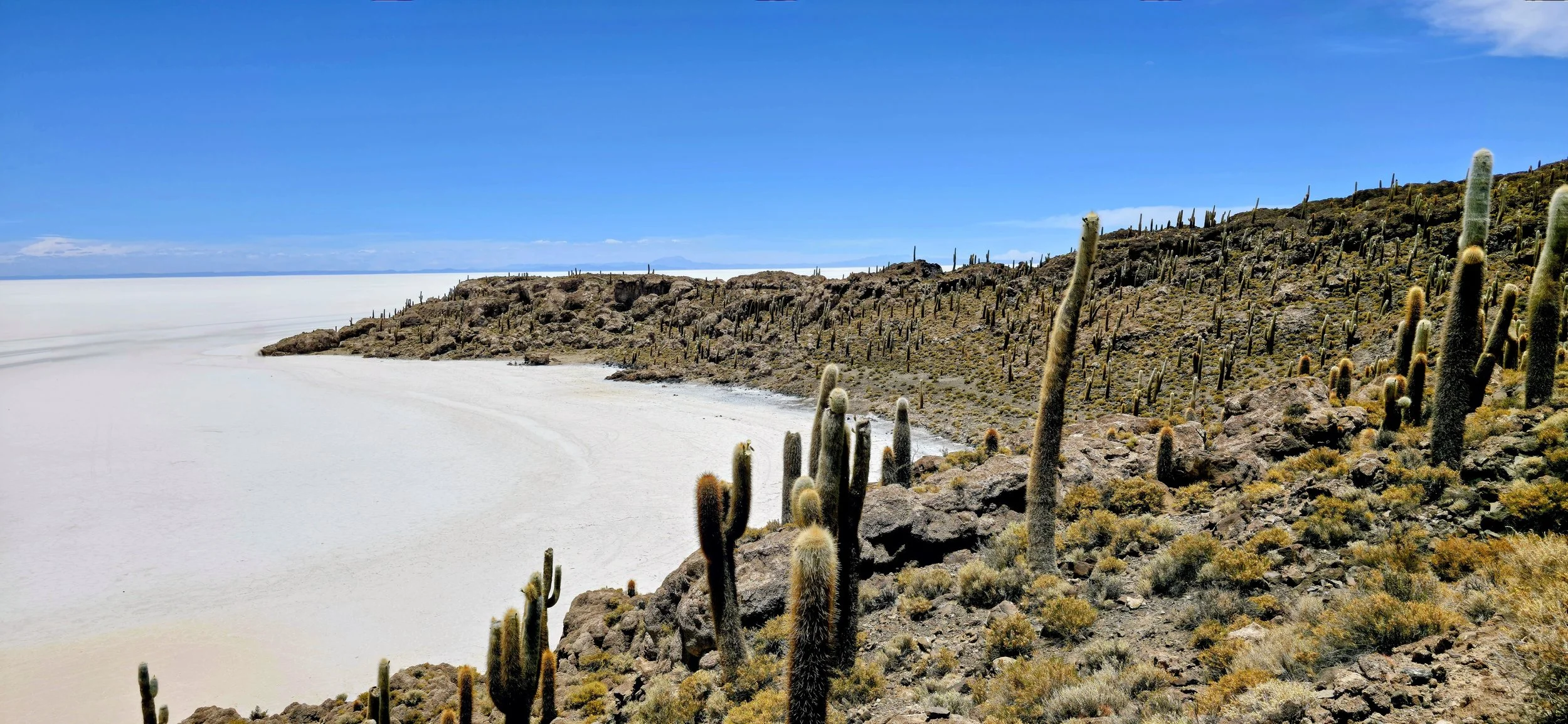
The drive from Dakar to Incahuasi Island (only during the dry season) takes about 1 hour. The island is a hilly, cactus-covered rocky outcrop situated in the center of Salar de Uyuni, the world's largest salt flat. Once a submerged volcanic peak in a prehistoric lake, it now serves as a surreal "island" in a sea of white salt, famous for its giant cacti and panoramic views of Tunupa volcano. Tell your driver you'd like to arrive early to explore before more people arrive. Once you park, start the climb up from the left side of the trail because it's more scenic and you should do it before the rest of the crowd arrives--the trail follows a "U" shape path. This photo was actually taken on the way down just before reaching the entrance area.
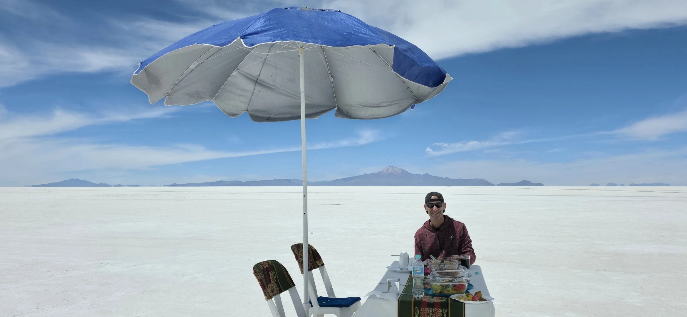
One of the coolest parts about the day was having Thanksgiving dinner in the middle of the salt flat. Upon request, my guides cooked up some local healthy options including grilled chicken, rice and vegetables. I had my guide take the photo with the Tunupa volcano in the background.
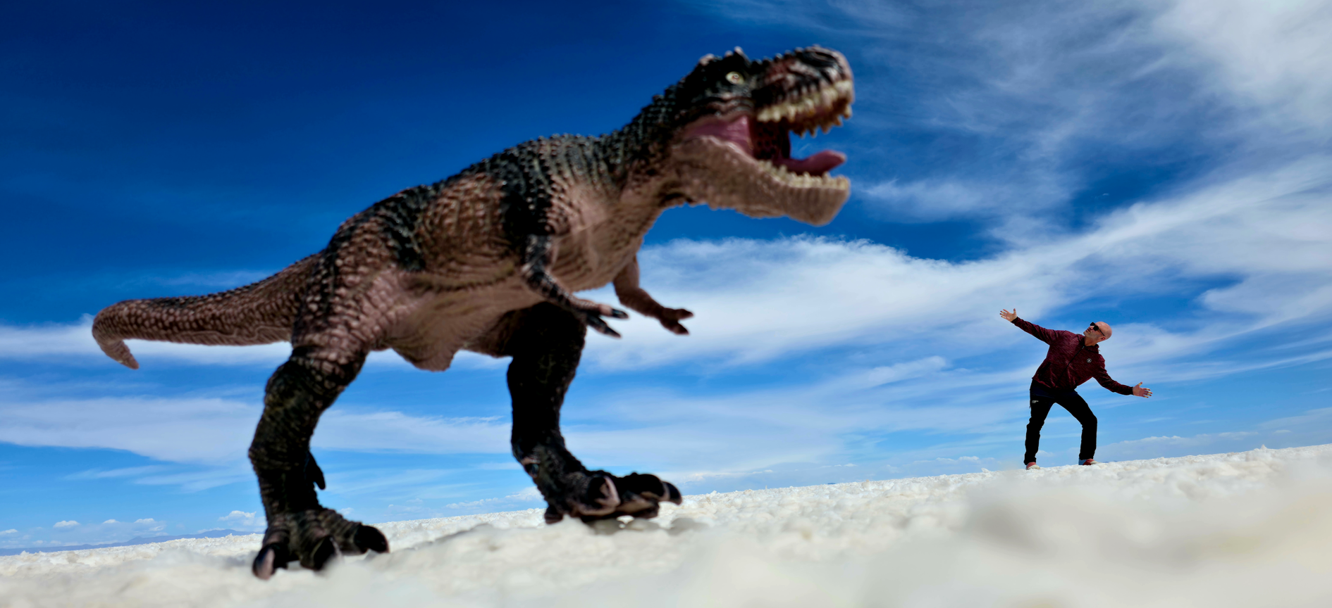
On the ride back to your hotel, your guides will likely make a pitstop in the middle of nowhere and offer props for capturing Instagram-famous photos. However my photos were not ideal because: 1) I did not visit during the wet season so the "mirror effect" wasn't visible, at least in this region of the flat and 2) I'm the least photogenic person alive, even after multiple attempts!
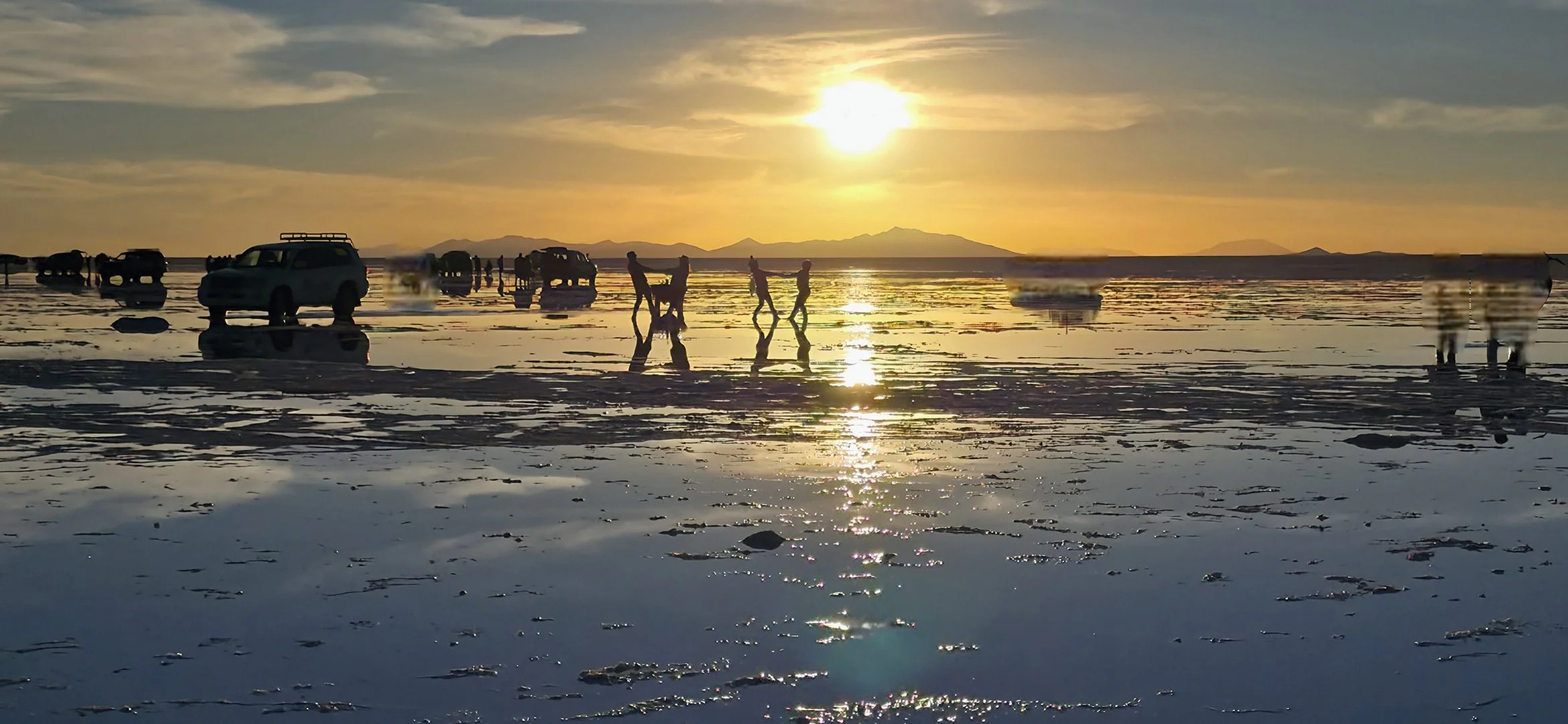
After a short rest at your hotel, the guides will take you to the day's final sunset destination, the Crystal and Salt Eyes, where you can capture more of the iconic mirror effects. Be prepared for crowds of tourists, but surprisingly, they enhance the photos in this rare case. This was the only time in Bolivia when I missed being in a larger group because it allows for more unique photo opportunities. To top things off, your guides will likely offer wine and snacks to celebrate the end of the day.
If you’re lucky, you’ll be treated to all kinds of unworldly mirror effects during sunset so make sure you’re always watching in every direction!
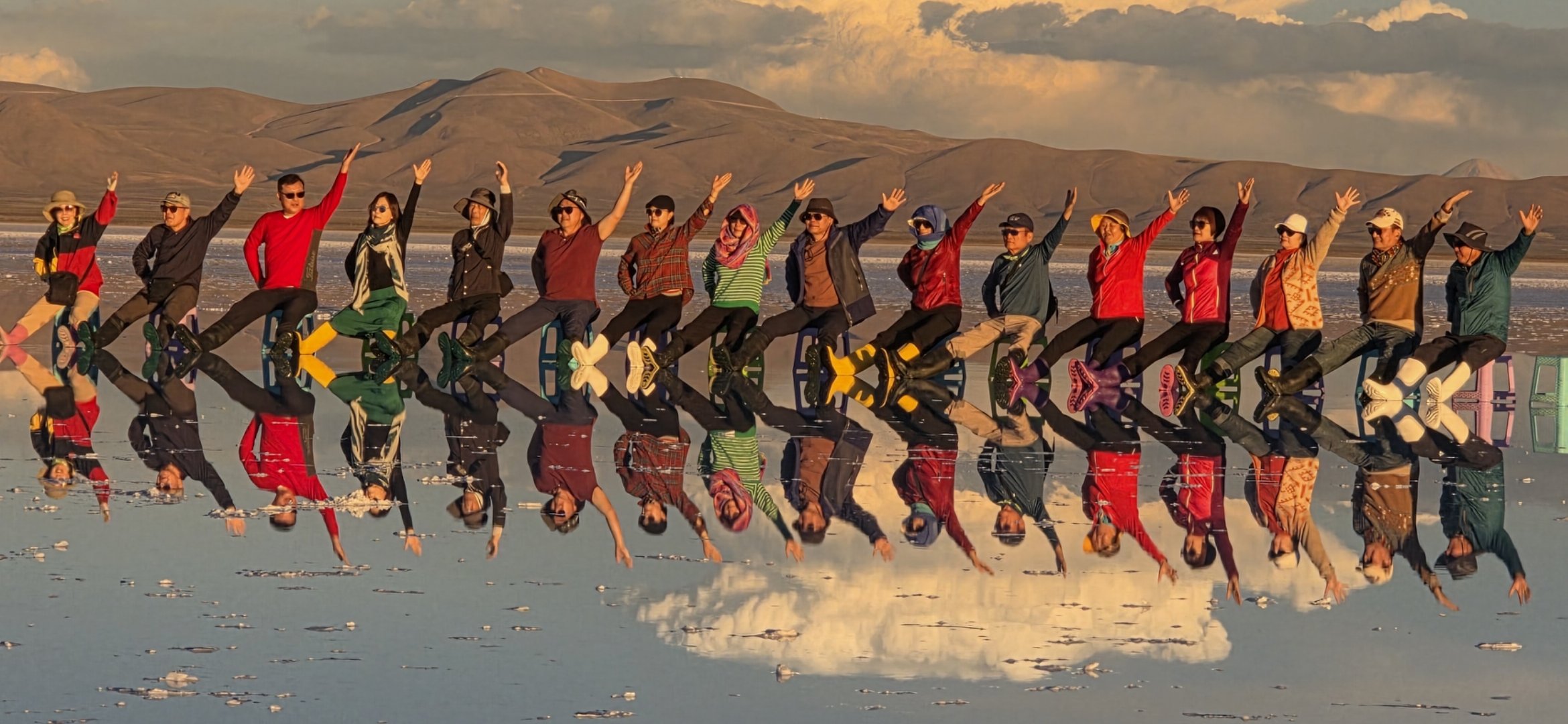
And lastly, I'm not typically one to take photos of other travelers, but I couldn't resist snapping this group from China. They came prepared!
Eduardo Avaroa Andean Fauna National Reserve
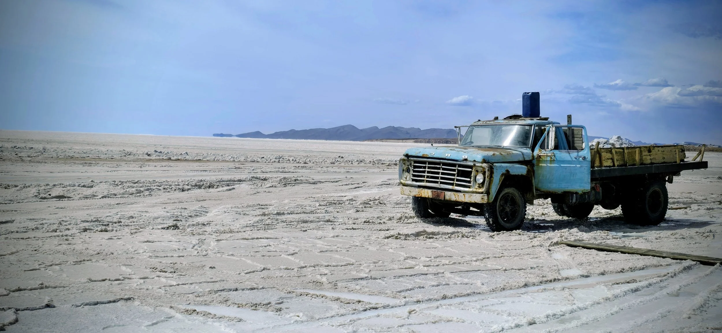
The Eduardo Avaroa Andean Fauna Reserve was one of my favorite parts of Bolivia! However, you should consider skipping a few short stops that will likely be planned in advance. Additionally, please be aware that the sequence of these activities might be slightly out of order because of a glitch in my photo library and I can’t recall it from memory. Colchani is a very tiny town located a few minutes from the Palacio Hotel, home to Bolivia's largest salt-processing cooperative. You will have the opportunity to purchase souvenirs, take a tour, and interact with locals. The photo on the left shows the main intersection, which is also easily reachable by renting a bike from the Palacio.
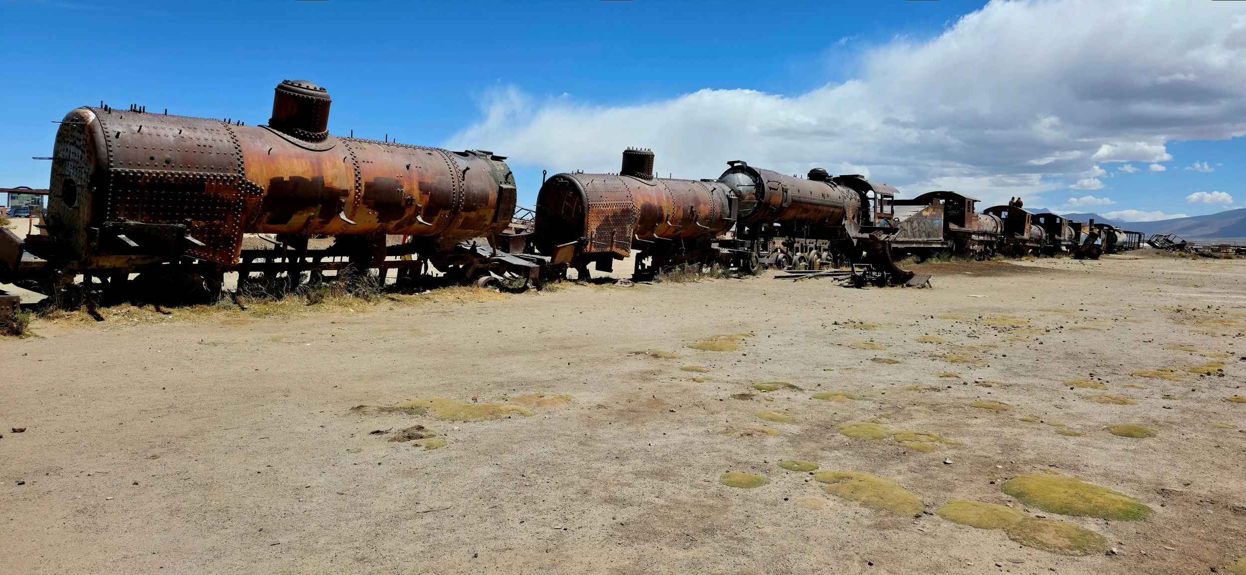
Another very popular attraction is the Train Cemetery in the city of Uyuni. Although the cemetery offers a very unique photo opportunity, it gets very crowded with tourists, and it wasn't my cup of tea. Arrive very early and then walk to the opposite side of the train for the best photo opportunity, as it should be empty there.
About an hour later, you’ll likely pull over at the famous rock formations, often referred to as part of the Valle de Rocas (Valley of Rocks), feature iconic, wind-eroded volcanic formations. The most famous individual rock, often resembling a condor's habitat or wings, is the Árbol de Piedra (Stone Tree).
If I had to do this all over again, I would probably stop at the Train Cemetery even earlier in the morning and skip the other two to have more time in the reserve.
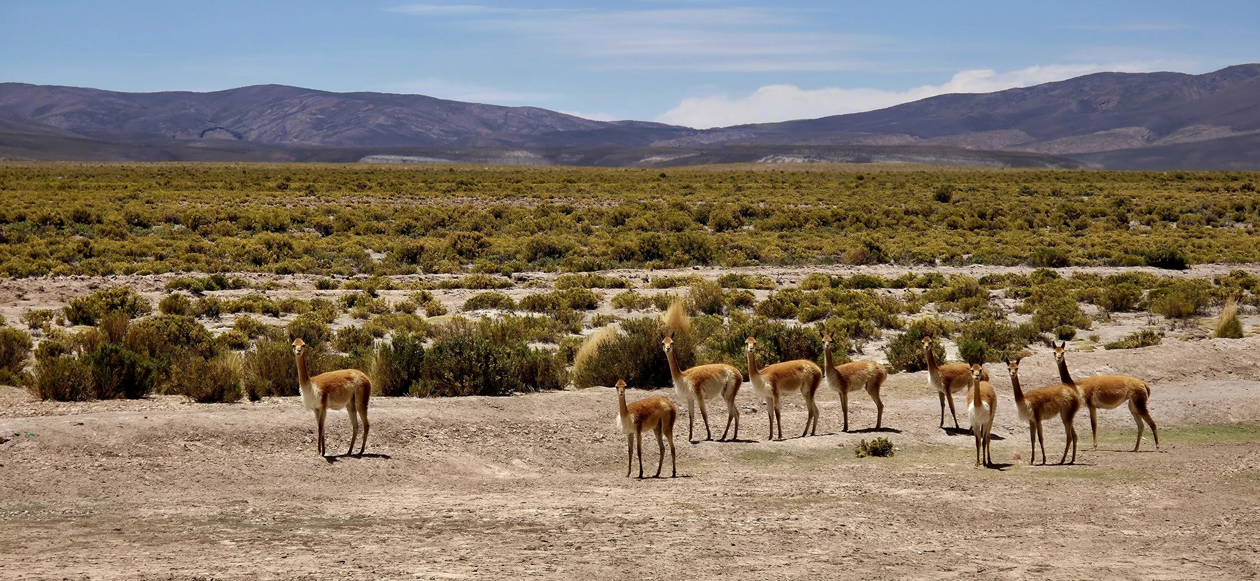
The exciting part of the reserve begins shortly after departing Valle de Rocas. This photo shows a group of vicuñas on the side of the road. The vicuña is a wild South American camelid and one of the four camelid types (along with llamas, alpacas, and guanacos) found in the Andean region of Bolivia. Vicunas are usually very timid and live in family-based groups (one male, 5-15 females, and young) or bachelor herds. They are very shy and highly sensitive to intruders, often running away when you exit the car. This photo took many attempts, but don't be disappointed if you miss your first opportunity--it's nearly impossible not to see a group of them every few hours.
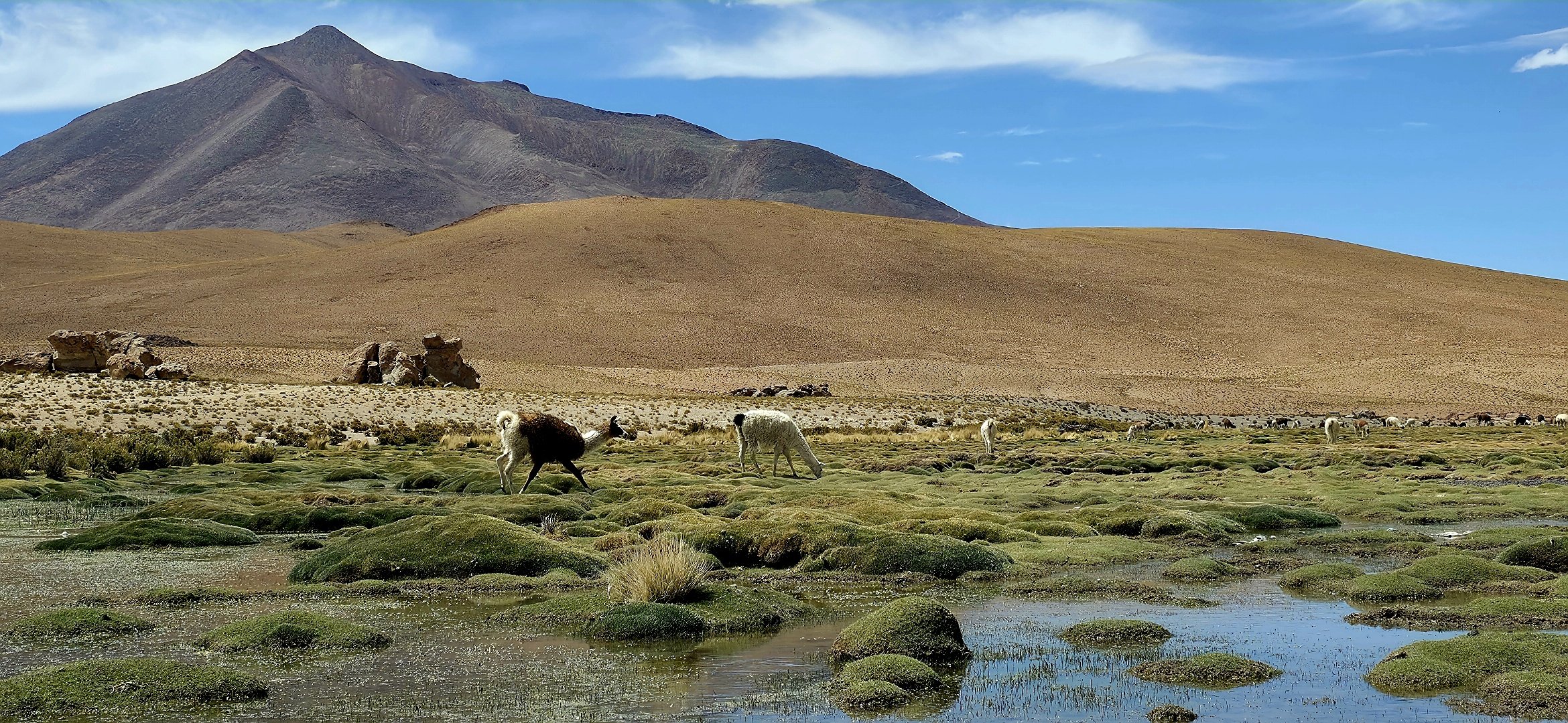
As you drive deeper into the reserve, the roads disappear and you'll whisk through the Andean desert via remnant tire tracks, racing and dodging boulders and exotic animals along the way. If it doesn't make you feel like you're on Mars, I don't know what will! Not long after traveling off-the-beaten-path, you will descend into a valley where hundreds of llamas roam freely. Interestingly enough, most Bolivian llamas have owners, but they don't mind if tourists approach them. This photo was taken about half way down the hill from the side of the road. You can even skip across those grassy moats to get super close to the animals.
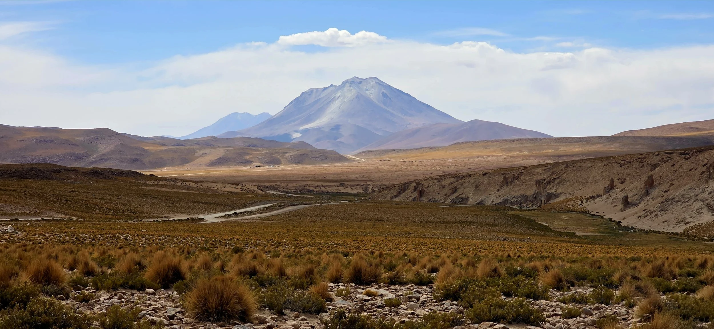
After another ~10 minutes of driving, you'll begin passing through a surreal valley with a majestic volcano directly ahead. Don't wait too long because the landscape changes rapidly. Exit your vehicle and walk about 50 yards into the brush on the righthand side of the road to capture this photo.
Within another hour (I can't remember exactly), the landscapes and wildlife will leave you even more in awe. You'll reach the first of many lagoons (Lagoon Cunapa) where thousands of wild flamingos make their home. Amazingly, the reserve does not fence off the flamingos, but you're technically supposed to stay behind the gravel path. Even more shocking is that you may see only a few other cars in a place that would otherwise be a zoo in the United States.
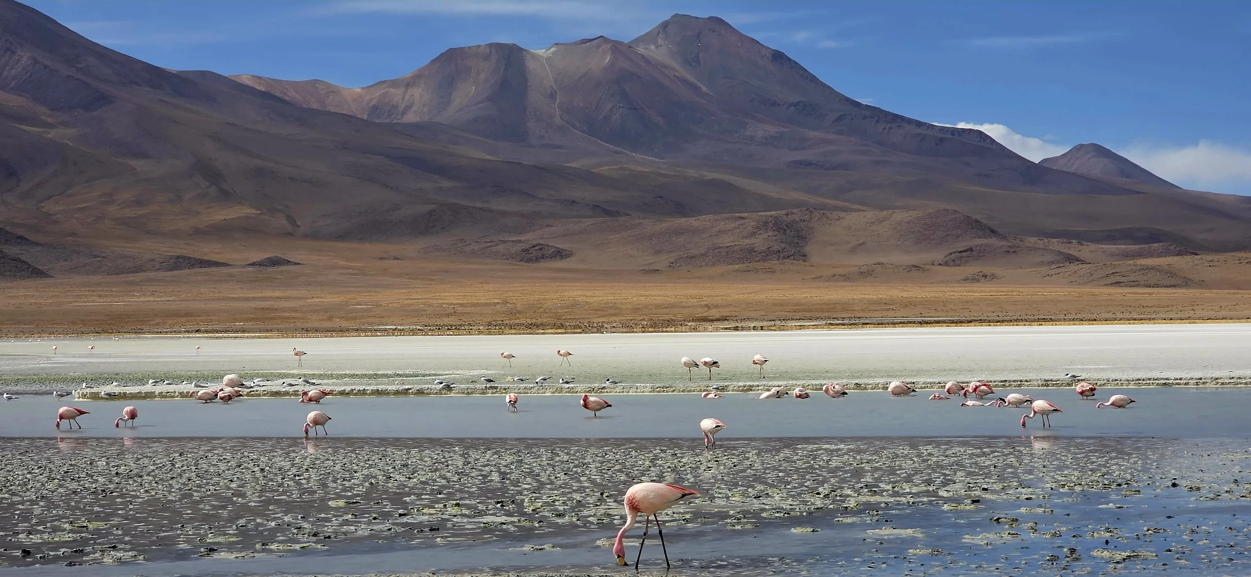
Lagoon Honda is next and even more mesmerizing because the water consists of bright teal blues and greens and the flamingos stand much closer to the roads. To get this photo, walk down to the lagoon and sit on one of the boulders to hold your camera steady. Technically, you're not supposed to get this close to the flamingos, but most of the private tour guides will look away as long as you're respectful.
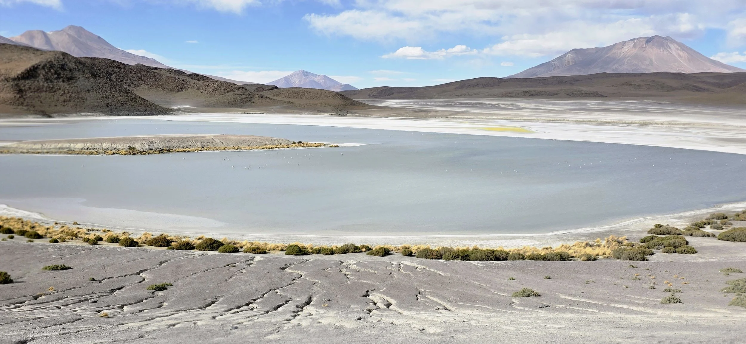
As you leave Lagoon Honda, you will slowly ascend on a dirt path that overlooks the lagoon and offers another spectacular, unworldly view of it. Exit your vehicle and walk slowly down the rocky hill to find this photo opportunity--beware, it could be very windy.
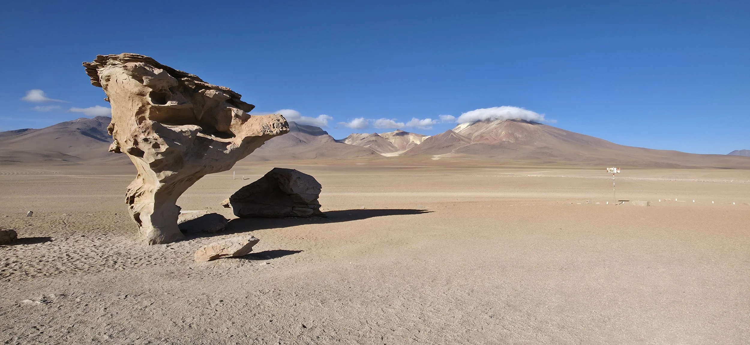
The next stop is the iconic 7-meter-tall Tree Stone, a volcanic rock formation sculpted by wind erosion in the Siloli Desert. Hundreds of other gigantic boulders, which resemble another planet, are unseen in this photo. This photo was taken about half way between the small parking lot and the tree stone. The location is a lot more breathtaking than this photo might suggest!
In the Siloli Desert, you will have many opportunities to interact with friendly Viscachas, a rabbit-like rodent closely related to chinchillas and commonly found in the rocky, high-altitude regions of Bolivia. These little critters can be very sociable because tourists feed them.
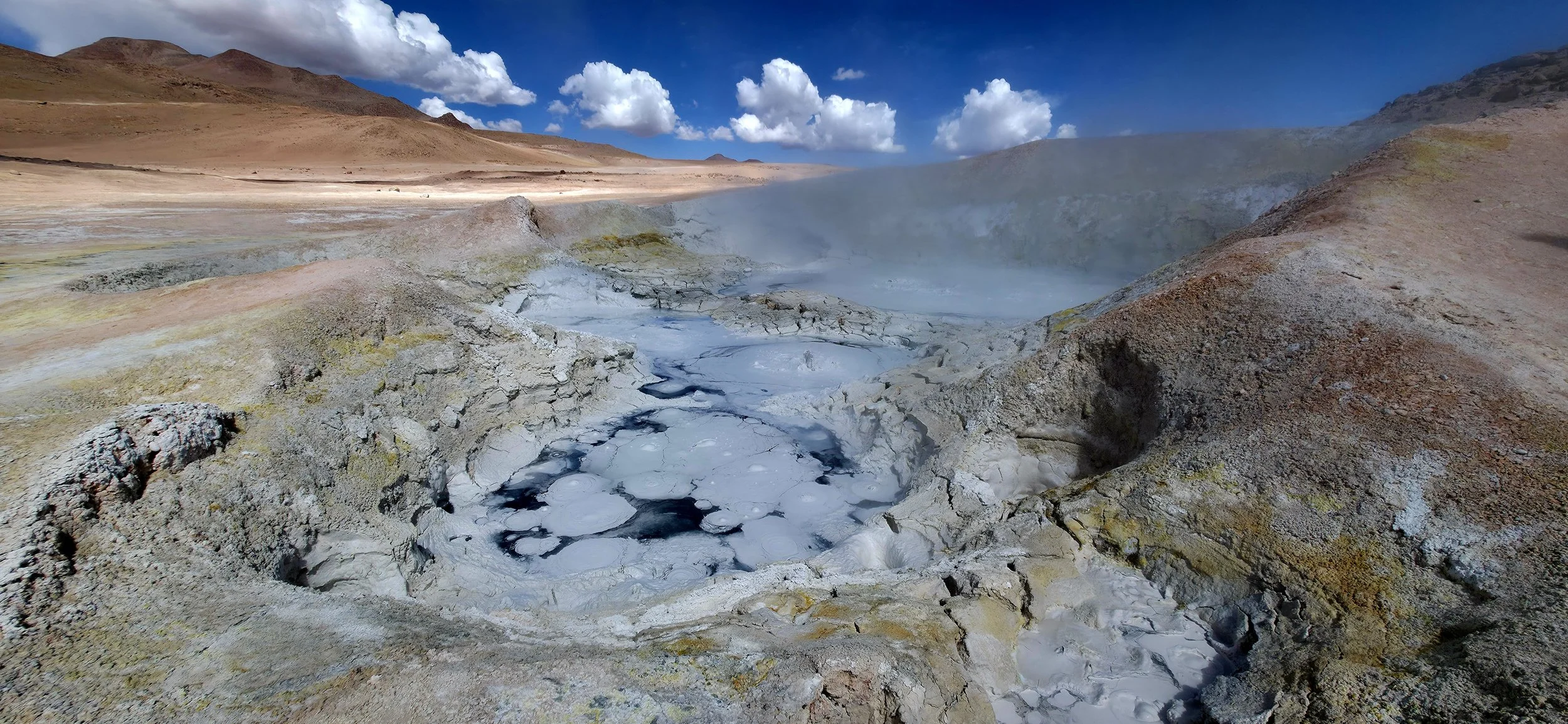
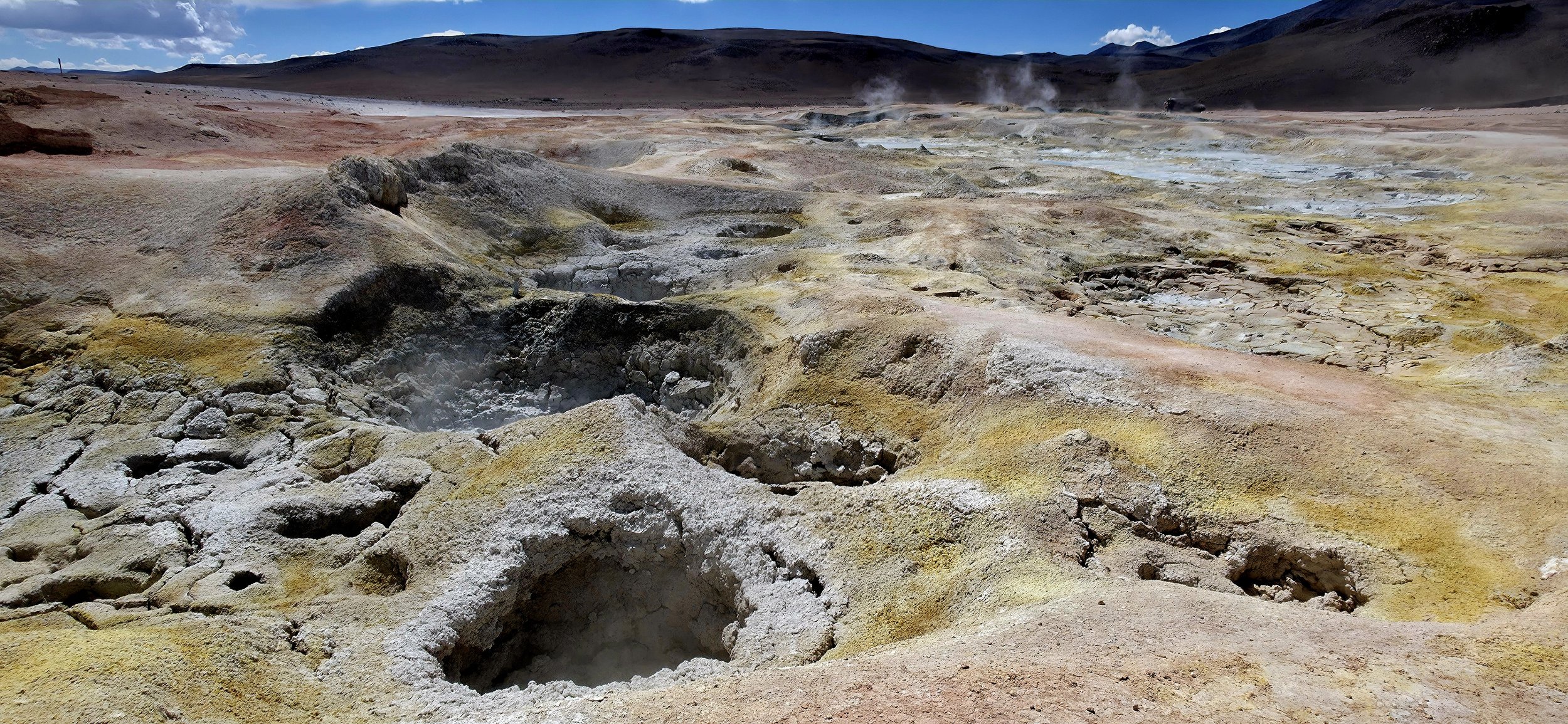
One of the reserve's most fascinating areas was the Geysers de Sol de Mañana (Morning Sun). These are high-altitude geothermal fields characterized by intense volcanic activity. The area features bubbling mud pots, roaring fumaroles, and steam plumes that can reach heights of up to 50 meters. Shockingly, there are no warning fences or walls to keep tourists away so you really can't be belligerent. That being said, the geysers are deep within the reserve so large crowds are uncommon. It's difficult to explain how to get this photo, but know that it's the most popular geyser in the area and impossible to miss. You might also be able to figure out the location by using the video below.
By this point, you will have driven 3 hours into the National Reserve with more to experience the next day. Included in the tour cost should include a one-night stay at the Hotel Tayka del Desierto. Hotel Tayka is an extremely remote, eco-friendly lodge located in the heart of the Siloli Desert that resembles a space station. It is famously situated at an extremely high altitude of approximately 14,700 feet, making it one of the highest hotels in the world! The rooms are a nice size and the bedding is exceptionally comfortable. However, the showers have limited hot water so it's important to wake up very early before it runs out. This is also one of the hotels where dehydration made it difficult for me to sleep and use the bathroom. This photo, taken from up the hill around sunrise, looks down at the hotel entrance.
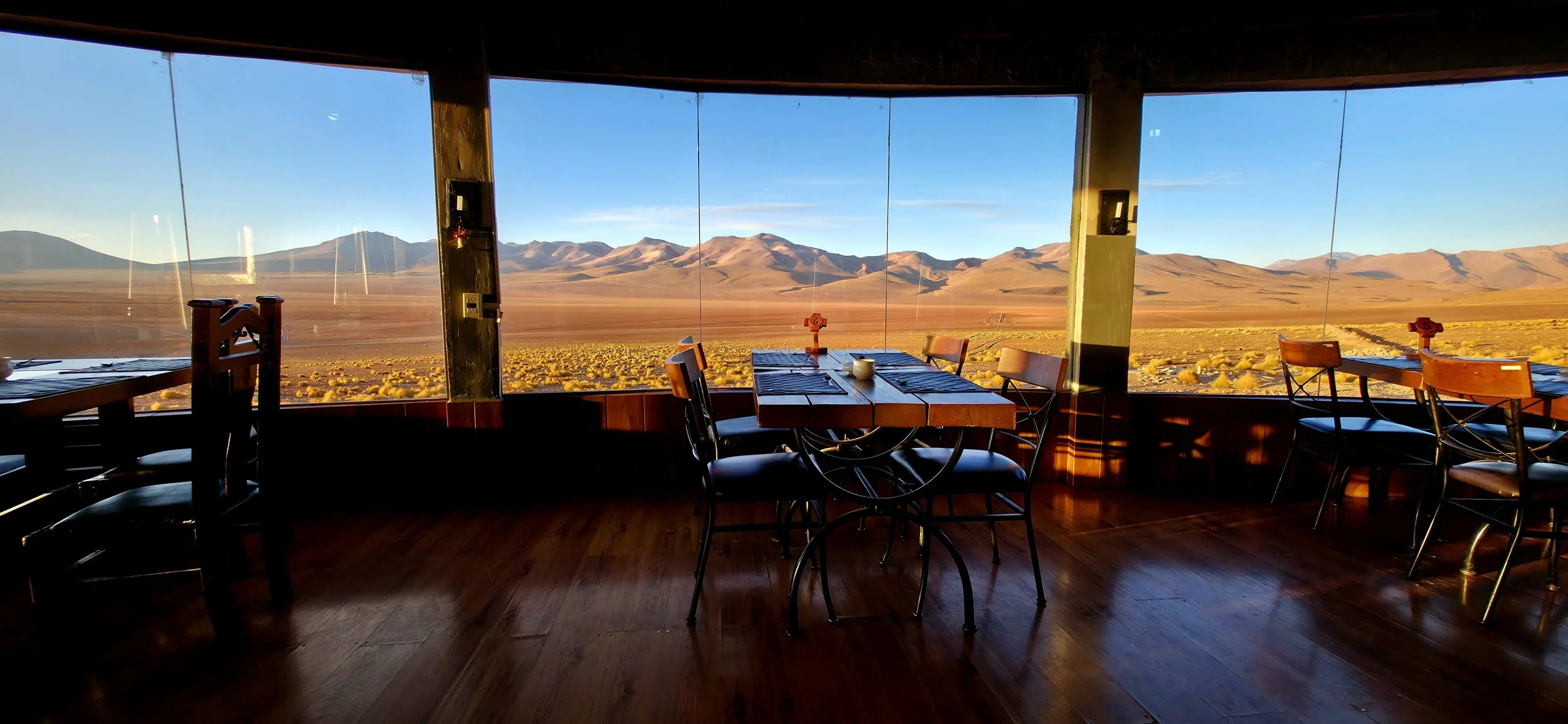
Once settled into Hotel Tayka, a nice dinner will be provided for all of the tourist groups, offering a great opportunity to meet other adventurous travelers. This photo, taken from the center of the seating area during sunrise, felt out of this world.
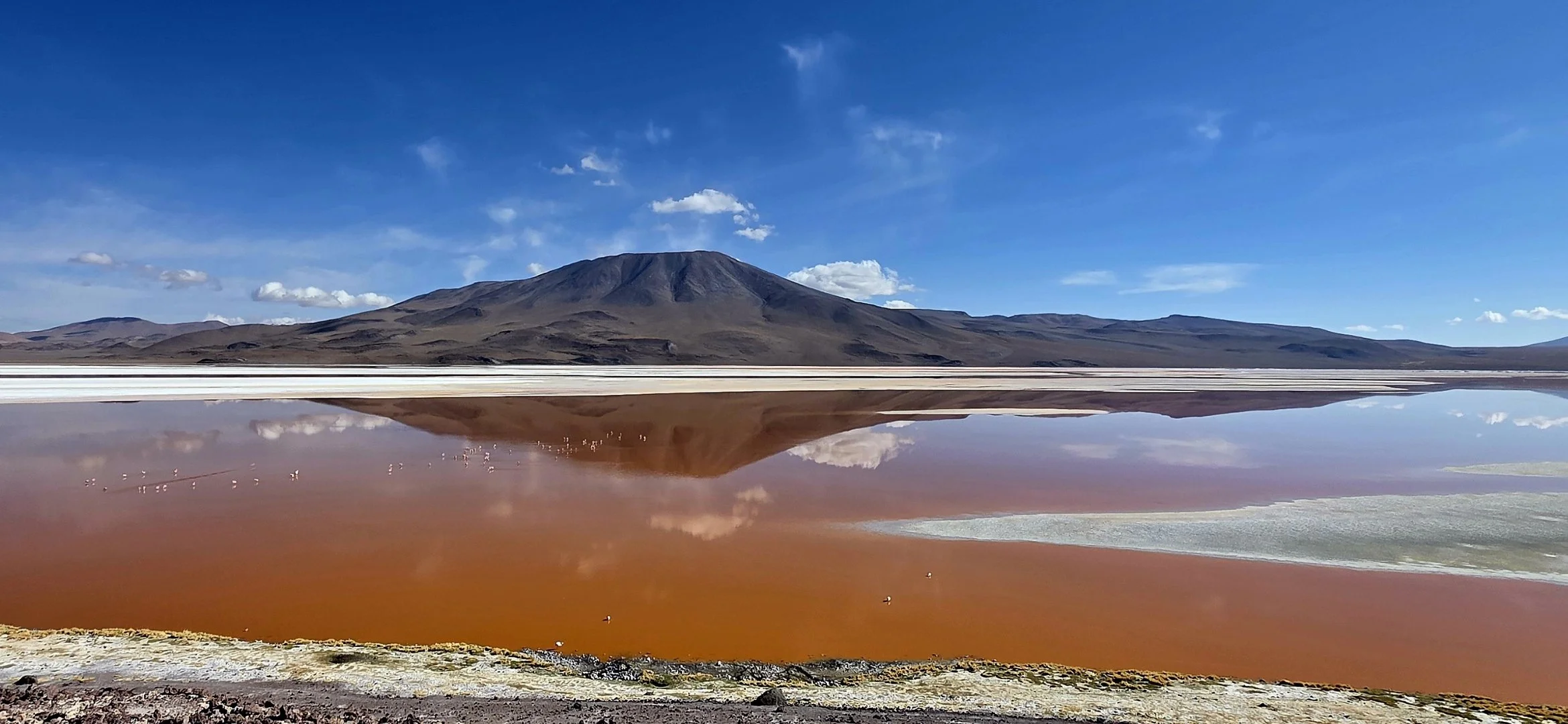
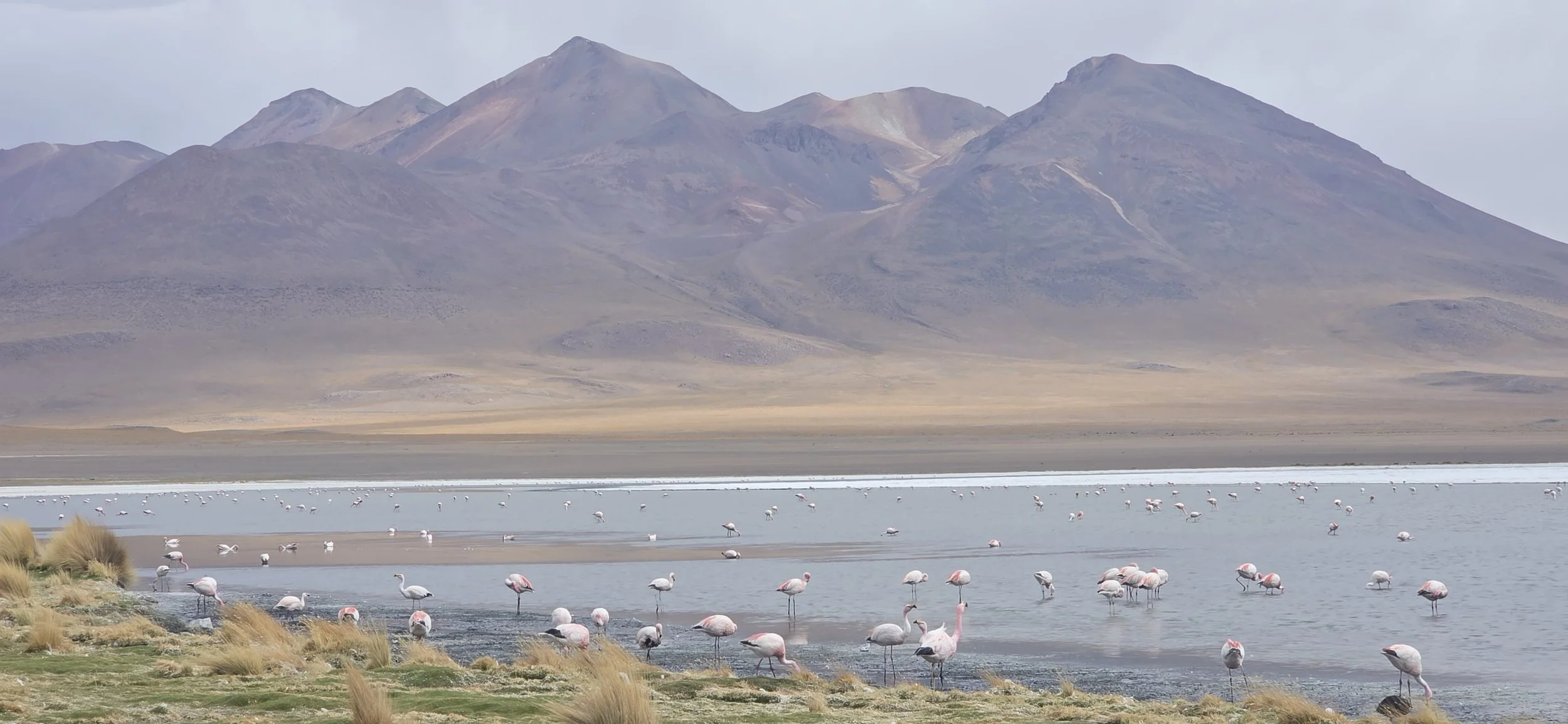
At the crack of dawn, your guides will drive another one to two hours to Laguna Colorada, a shallow 15,000-acre, high altitude salt lake known for its striking red color caused by algae and sediments. It's also a primary nesting site for thousands of rare Andean and James's Flamingos. They might ask if you'd like to stop at the Hot Springs on the way, but it's not worth it in my opinion. I recommend skipping the springs and getting to Laguna Colorada earlier to have more time to explore before the crowds appear. This photo was taken from the very last lookout point which is the lagoon's most vibrant red section. You can also walk down the hill to get closer to the flamingos, but the view isn't as striking.
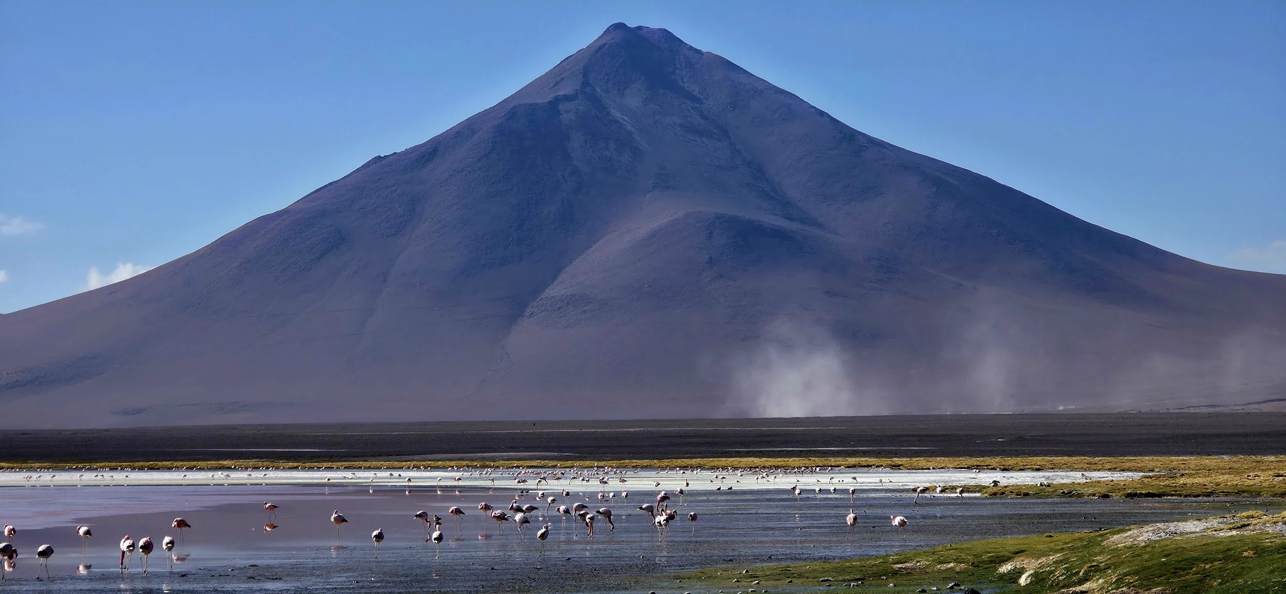
Here is another vantage point from Laguna Colorada, but this one is from the bottom of the hill, looking in the opposite direction of the photo above. As a heads up, the flamingos will quickly flock to other areas of the lagoon if you get too close.
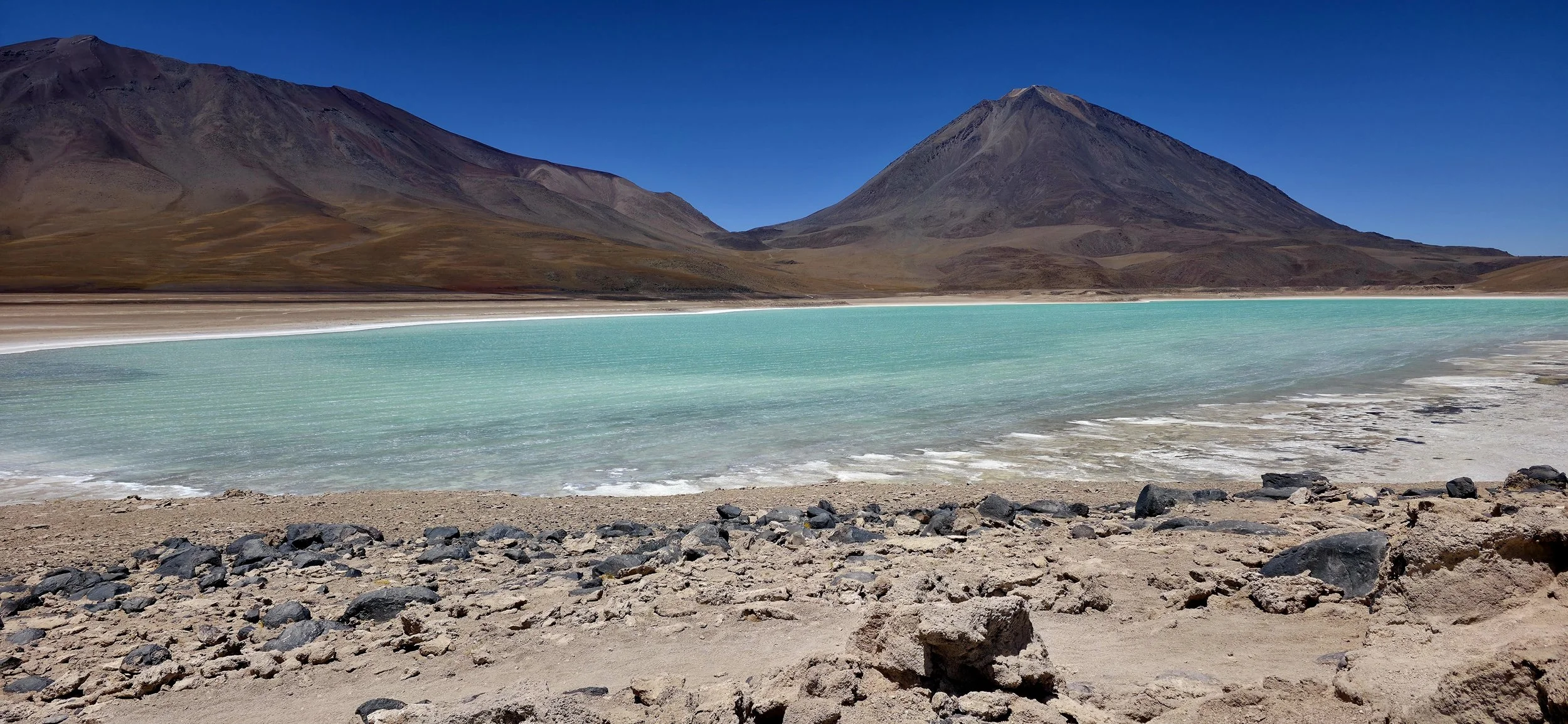
The last stop in the reserve is Laguna Verde, a stunning high-altitude salt lake located near the border of Chile. It is famous for its vibrant green-to-turquoise color and its dramatic setting at the foot of the Licancabur Volcano. You might be one of a few tourists to reach this final destination because it is so deep within the reserve and most tours do not make it this far. This panoramic video was taken from the path on top of the cliff, looking down at the lagoon.
From here, you will start the four-hour journey back to your hotel in Uyuni, potentially stopping at a few more smaller lagoons along the way. Your guides will also stop in San Cristóbal to visit the local market and fill up the gas tank. San Cristobal is a very small town in the Potosi Department known for its colonial-era church and significant open-pit silver, lead, and zinc mine. However, I wouldn't expect to take any noteworthy photos here.
La Paz
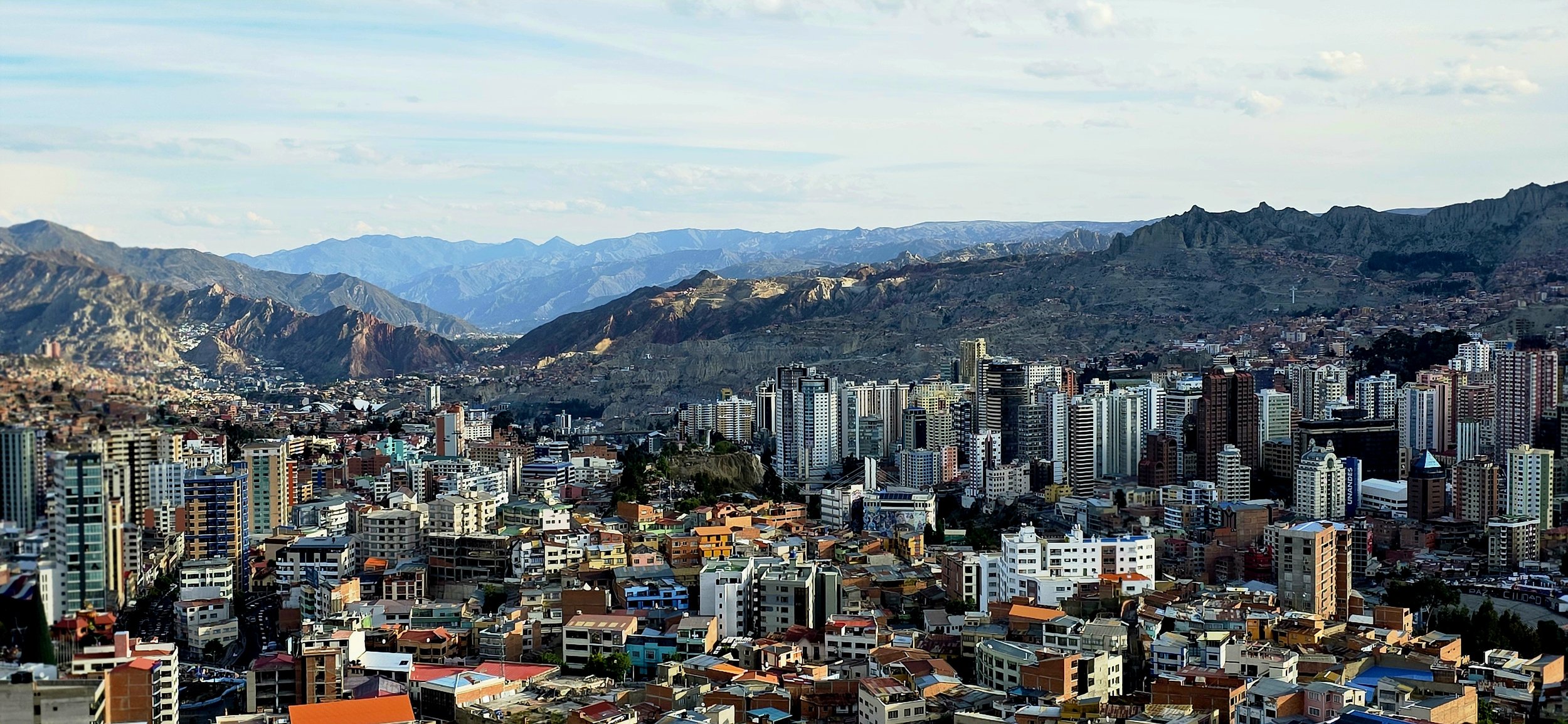
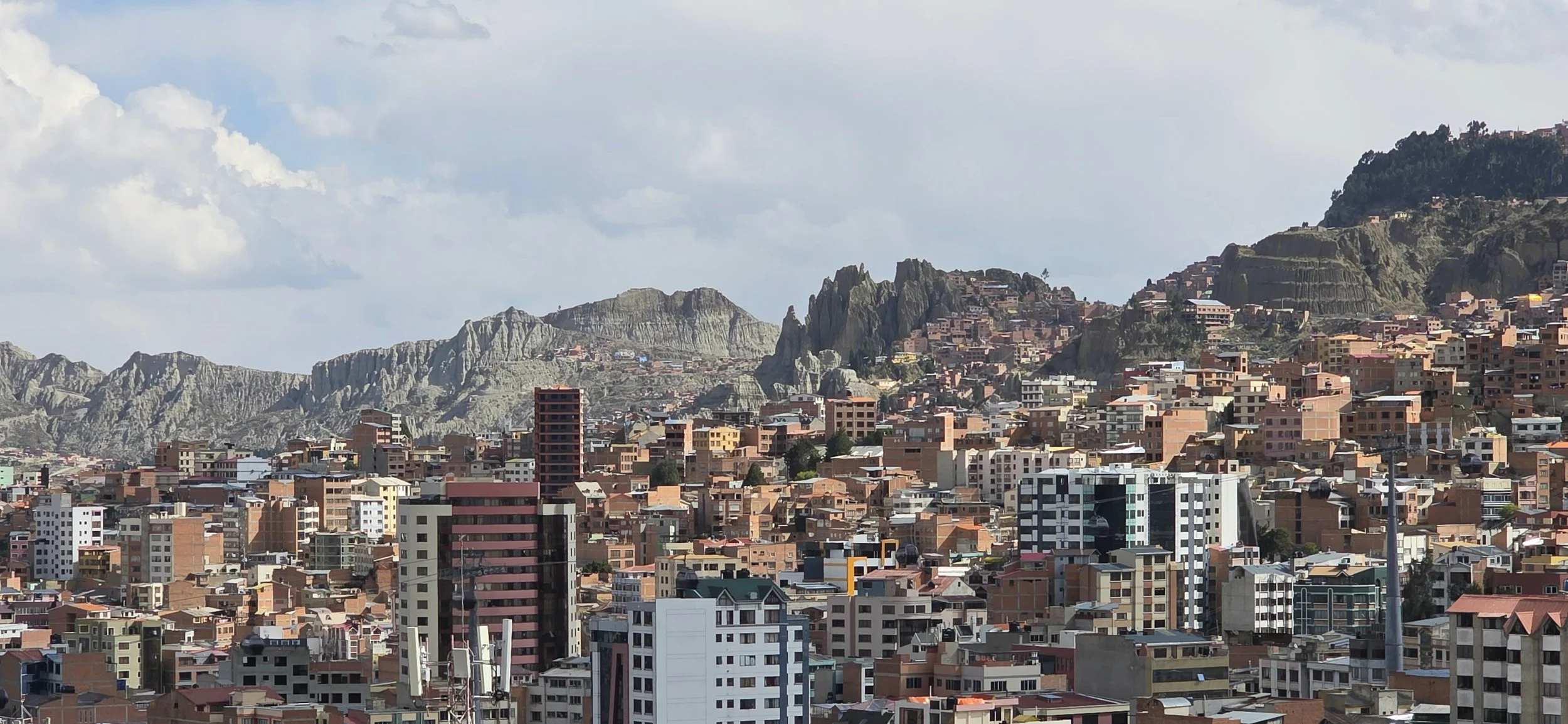
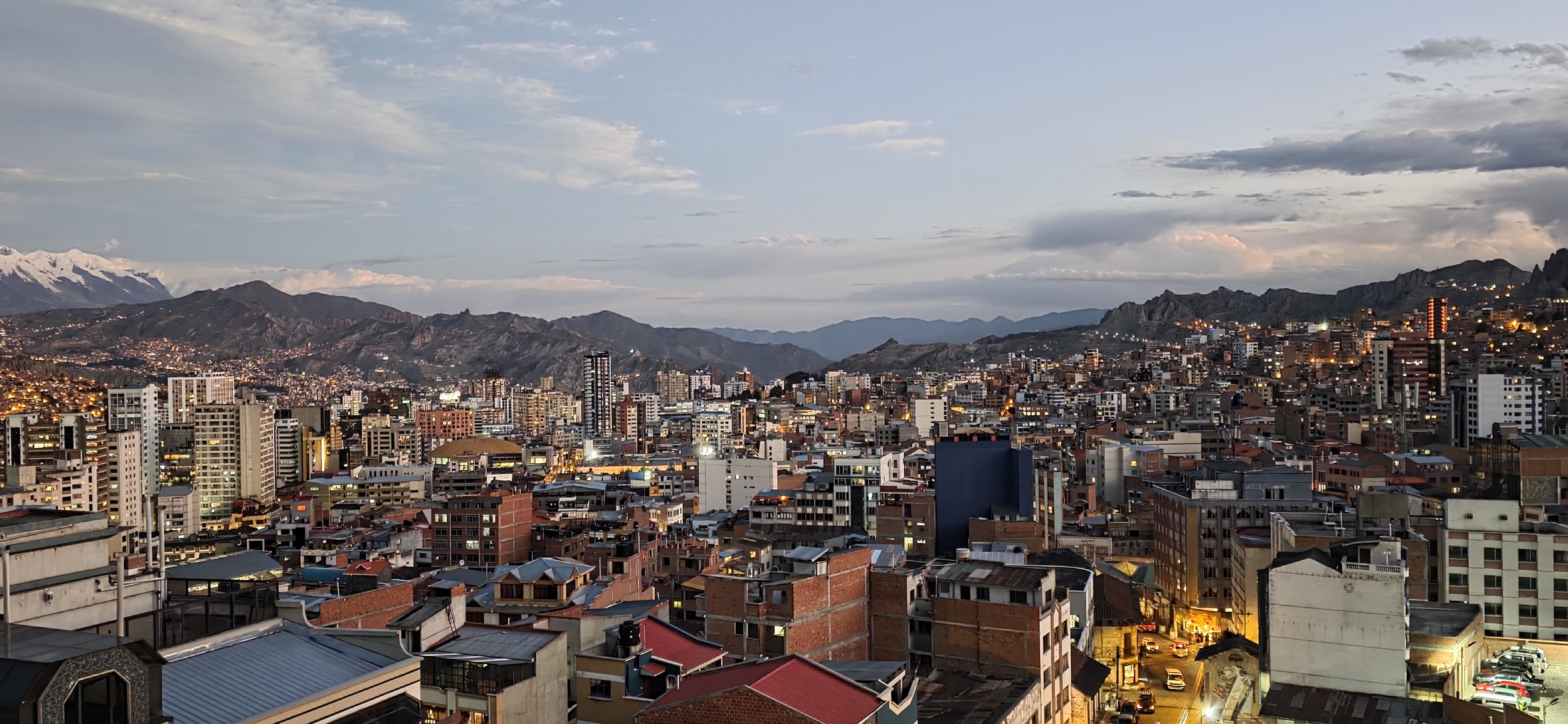
La Paz is the world's highest administrative capital city, nestled in the Andes at altitudes ranging from 11,000- 13,500 feet. It is a city defined by its dramatic topography, vibrant indigenous culture, and a unique urban transport system that floats above its crowded streets. The taxi ride from the airport to the Zona Sur hotel was one of the most jaw-dropping rides of my life; you drop 2,000- 3,000 feet while snaking through third world neighborhoods, and the entire city below looks like it was built on top of Mars. The remainder of this blog is in no particular order since you can use La Paz as your home base for all these activities. Lastly, this photo was taken from one of the city's most popular miradores (lookouts), which is covered below.
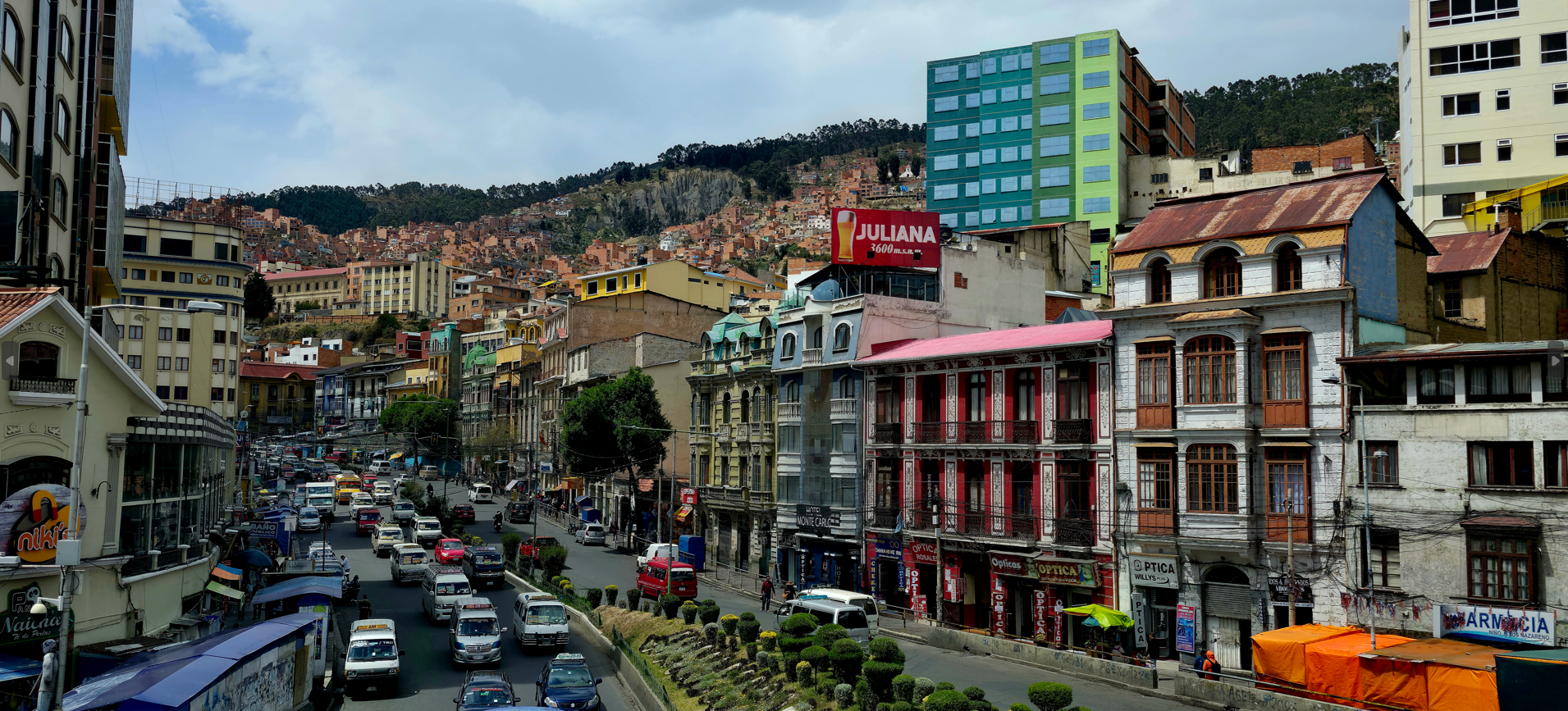
The Centro Historico of La Paz, also known as Casco Viejo, is the city's colonial and political heart. Characterized by steep cobblestone streets, vibrant plazas, and a blend of Spanish and indigenous architecture, the area contains the city's most significant landmarks. In my opinion, you can easily visit the most noteworthy sites—Plaza Murillo, Plaza San Francisco, Calle Jaen, The Witches Market, and Mercado Rodriguez—in one day without hiring a guide. Although the area looks underdeveloped and few tourists are visible, it is generally very safe; however, be a little more careful at night. If time permits, there is much more to visit in the area, or you can just wander for hours like me. This photo was taken from the busy Perez Velasco Pedestrian Bridge, the city's most famous footbridge, which crosses over Avenida Mariscal Santa Cruz.
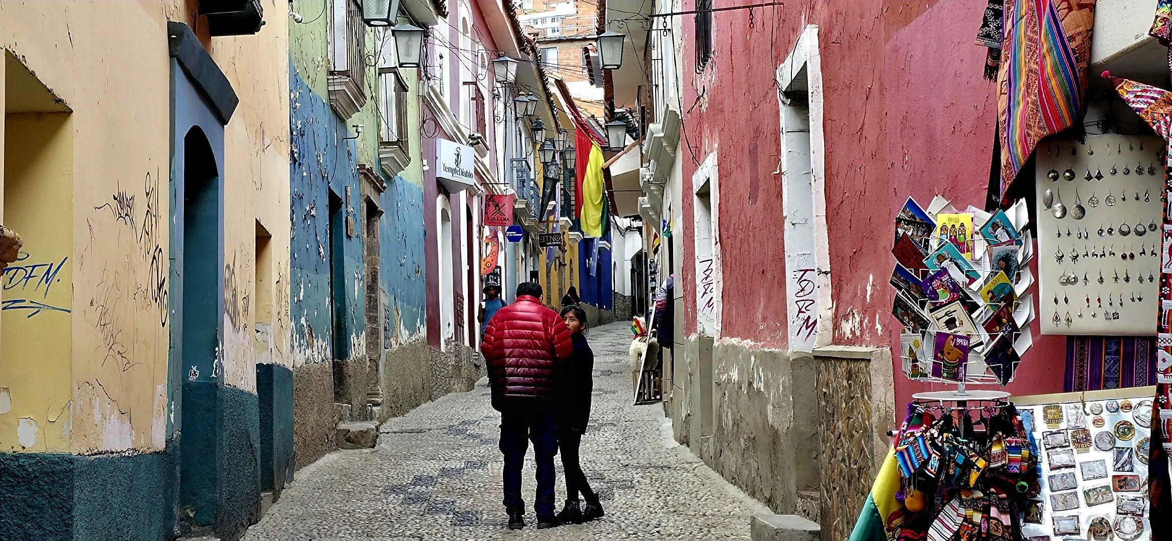
Calle Jaén is widely considered the finest colonial street in La Paz, known for its remarkably preserved 18th-century architecture, vibrant colors, and cobblestone paths. It's actually a short pedestrian alleyway that's a bit overhyped in my honest opinion, but still worth checking off the list. The pathway has a slight incline and this photo was taken from the bottom, looking up.
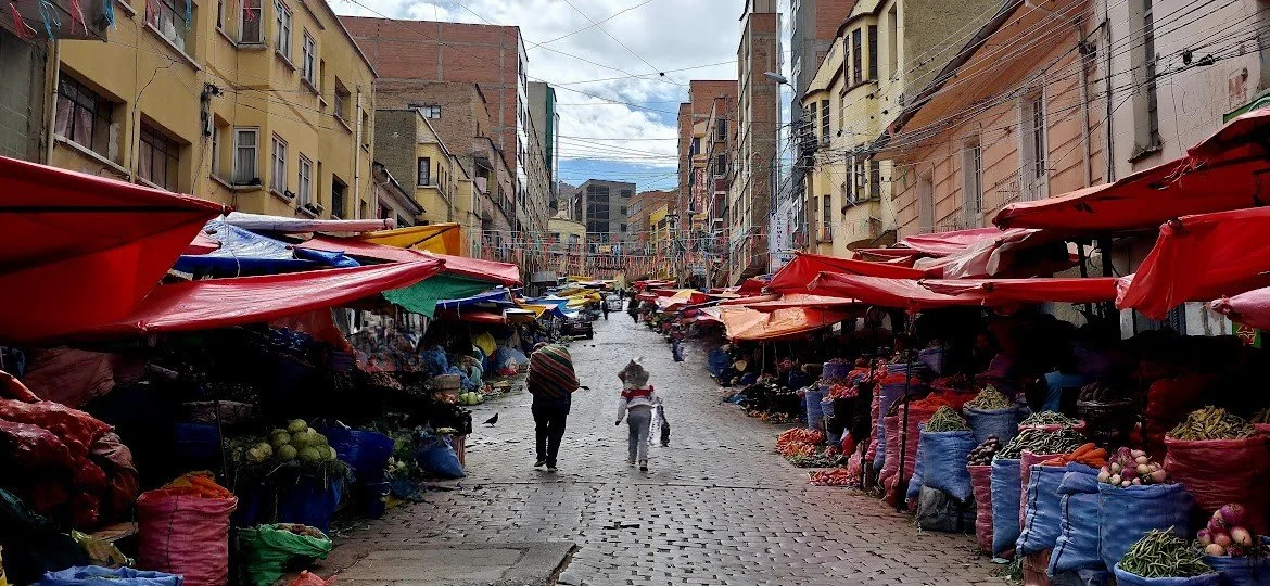
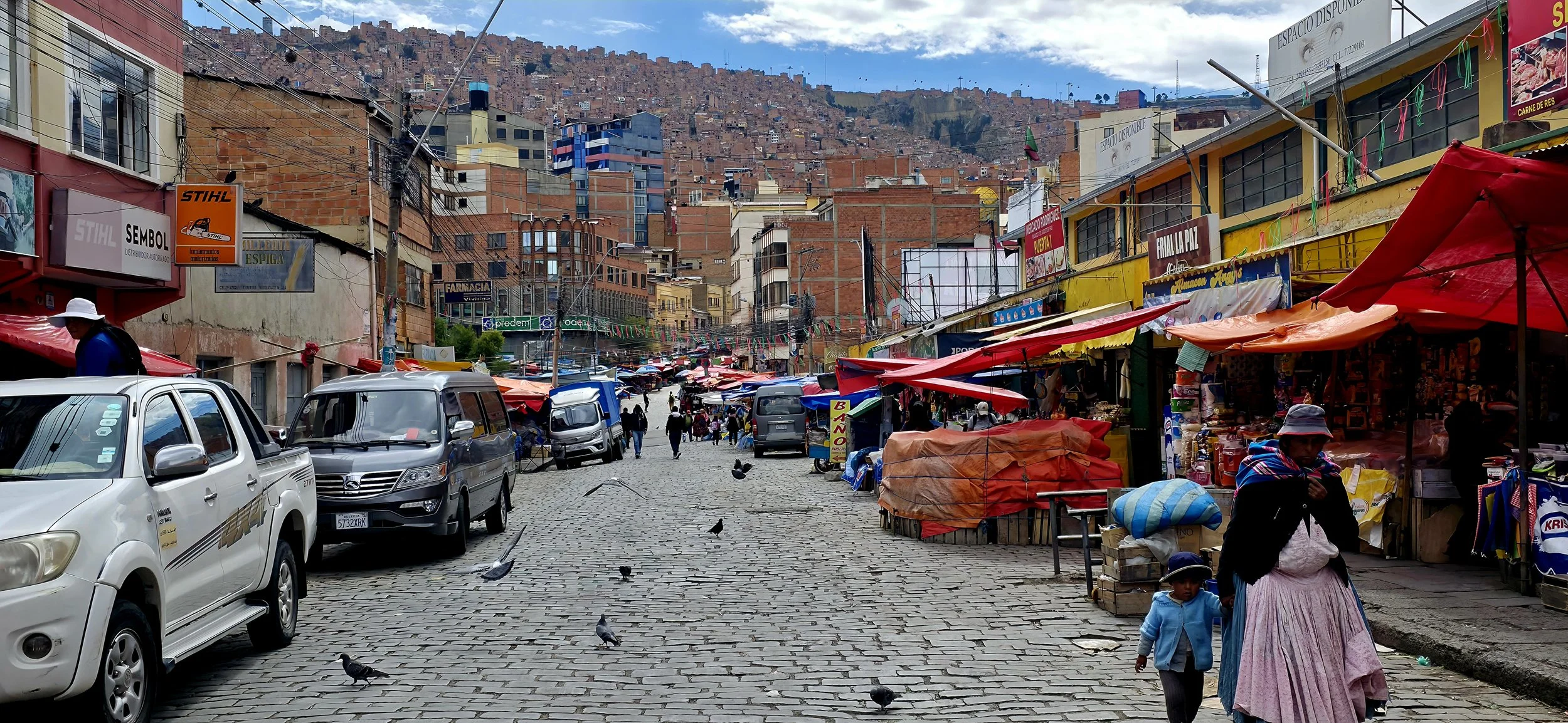
Mercado Rodriguez in Centro Historico, is La Paz's largest and most vibrant food market, where locals shop for fresh produce, meats, and household essentials. Unlike the more tourist-oriented Witches' Market nearby, Mercado Rodriguez offers an authentic glimpse into daily Paceno life. The best time to visit is during the lively Friday and Saturday mornings, as more vendors travel from the countryside to sell their freshest harvests. My favorite snacks to buy were the pasankallas, often referred to as Bolivian popcorn; some contain much more sugar than others. This photo, taken from the main street, Calle Rodriguez, features a mother and son in their traditional Bolivian clothing. Note: It was raining and the market was closing shortly so expect it to look much different during a nicer time of day.
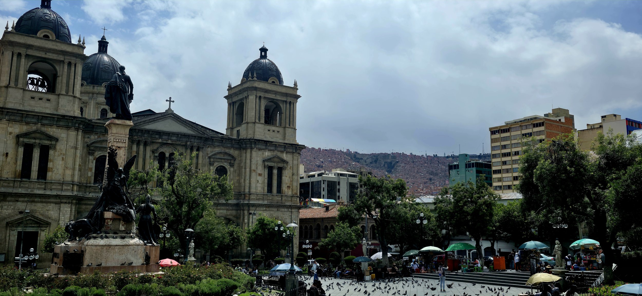
Plaza Murillo serves as the city's central square and "Kilometer Zero" for the country's road network. The plaza is famously surrounded by Bolivia's most significant administrative and religious institutions: the Palacio Quemado, Casa Grande del Pueblo, Catedral Metropolitana, Central Monument and Palacio Legislativo. The square is also a lively gathering place where locals and tourists feed thousands of pigeons and watch political rallies or cultural performances. Transparently, the plaza was a bit underwhelming compared to some of the other sites in Centro Historico. Additionally, this isn't a very photogenic location, but standing on the steps facing the monument with the Palacio Legislativo in the background is probably your best bet.
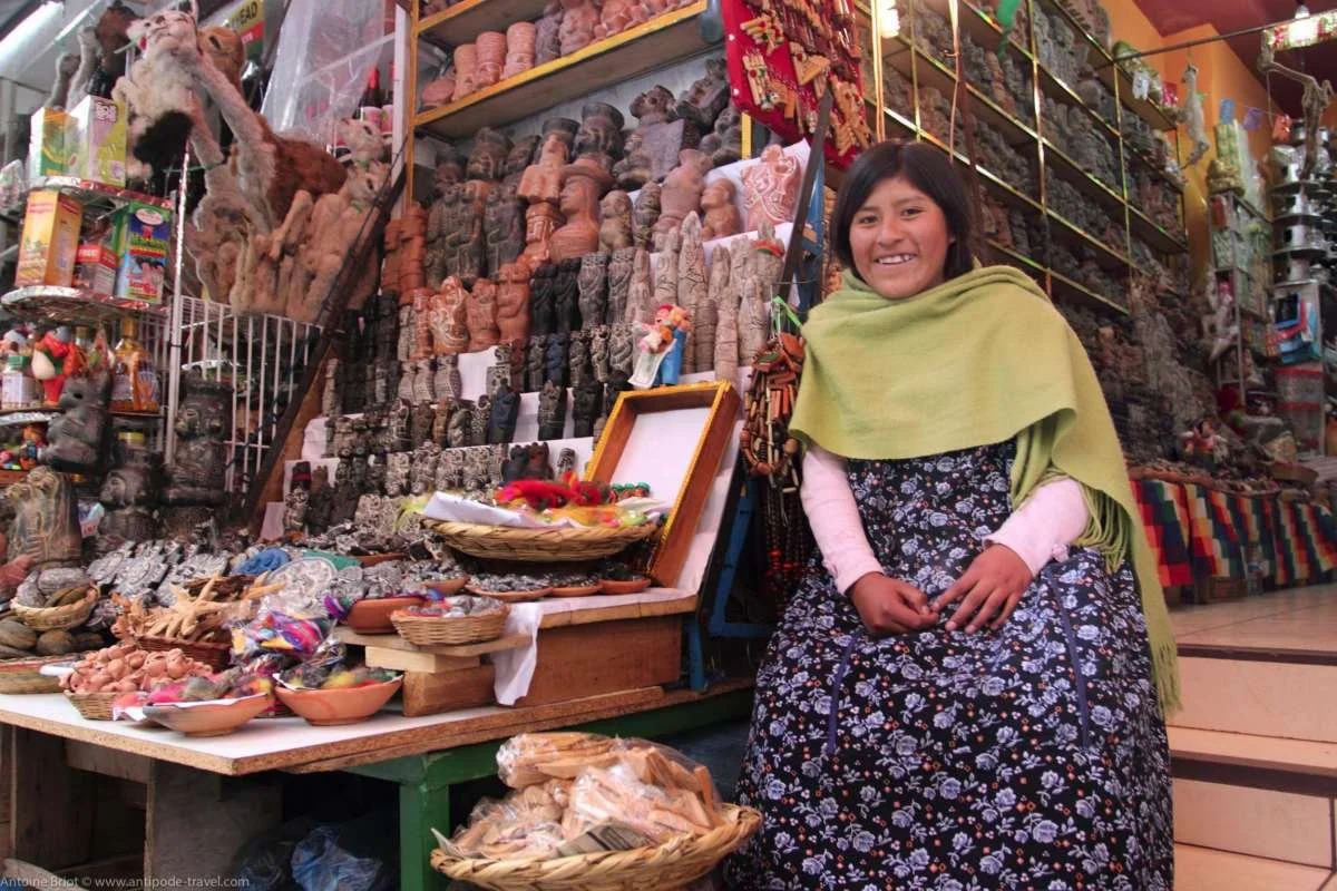
The Witches' Market (locally known as Mercado de las Brujas) is one of La Paz's most famous and culturally significant attractions. Located in the Centro Historico, it's a hub for Aymara traditions, where spiritual beliefs and everyday life intersect. Most stalls typically open daily around 9:30am and close by 7-10pm. The market offers a mix of authentic ritual supplies used by locals and handicrafts for tourists. It honestly reminded me of many Central and South American cities with colorful umbrellas suspended over the streets. Some people advised me to always ask permission before photographing vendors, as some consider it disrespectful or bad luck, however, I didn't notice any such reaction. I enjoyed walking through this area, but it was definitely the most touristy spot in Centro Historico. Unfortunately, I somehow misplaced my Witches' Market photos and had to find something from Google for now.
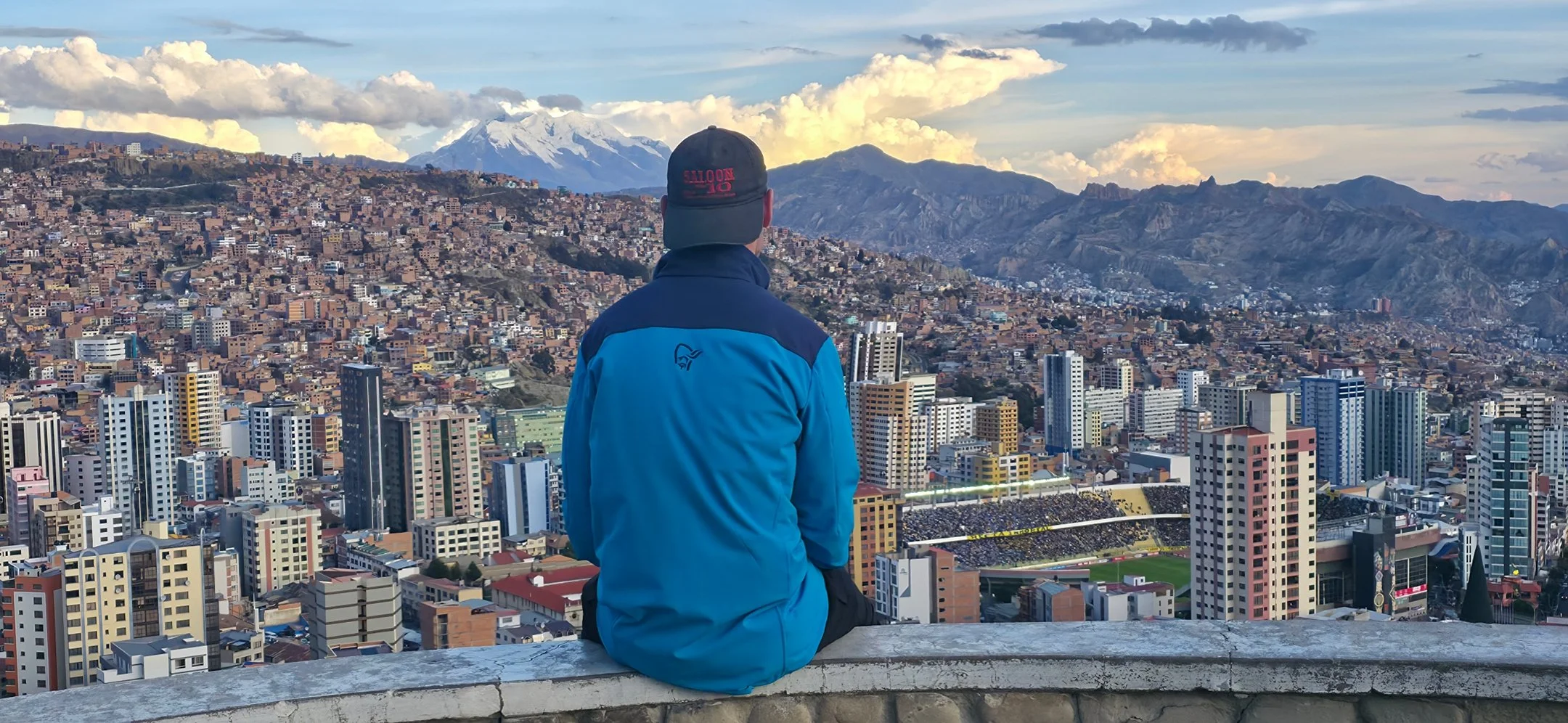
A great way to finish the day is by visiting Mirador Killi Killi during sunset. The Mirador is one of the most famous and central viewpoints in La Paz, offering a nearly 36--degree panoramic view of the city's unique "bowl" topography. It is located atop a steep hill in the Villa Pabon neighborhood. It is a roughly 10-15 minute walk from Centro Historico, but the climb is extremely steep and physically demanding. I recommend taking a Taxi or Uber since they are affordable and can drop you off directly at the entrance. Entry should be free, and bring a jacket because it can get windy and cold at the top. The location is generally considered safe during the day, but I wouldn't walk back at night. If you're able, visit during a soccer game for a more fun experience. On a clear day, Mount Illimani, the second-highest mountain in Bolivia standing at 21,122 feet, can be seen in the distance. This photo spot is impossible to miss, but I'd be cautious about standing on the ledge, which you'll likely see others doing a lot. The first large photo in this section was also taken from Killi Killi but from a more central area of the lookout.
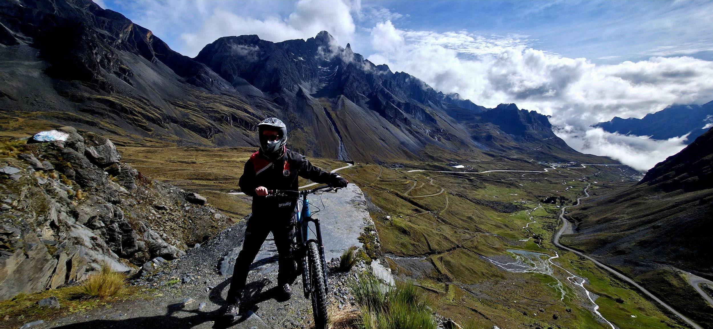
If you're an avid adventure seeker, you absolutely MUST try biking "Death Road." Yungas Road, universally known as "Death Road," is a legendary 64-kilometer route connecting the high-altitude city of La Paz to the subtropical Yungas region. Historically dubbed the "World's Most Dangerous Road" due to an annual death toll of 200-300 people, it has transitioned since 2006 into a world-famous destination for adventure tourism. I booked an all day private tour via Gravity Tours which costs approximately $500 USD, including extra insurance and tolls encountered on the way. For those who want a more extreme experience, they offer another tour that starts even higher up in the snowy mountains, but it was already cold enough for me. Make sure to leave yourself an extra day in case you need to reschedule due to inclement weather. Gravity will pick you up at your hotel around 6am and take you to a local neighborhood breakfast spot closer to the starting area. You'll arrive at the lake shortly after breakfast and they will provide all safety instructions and gear before the journey begins. I recommend wearing their gear at the top for the cold weather, but pack it away once you reach the official start of Death Road, as it will become much warmer and the clothing is unflattering for photos. From there, finishing the ride might take another four to six hours, but this can greatly vary based on experience level and break frequency. You might not return to your hotel until 7-8pm. Be prepared that your guide's English skills might not be the best. This photo was taken approximately ten minutes into the ride at one of the pull-off overlooking the valley. Be advised that Gravity's photo skills are horrible so you'll need to instruct them carefully.
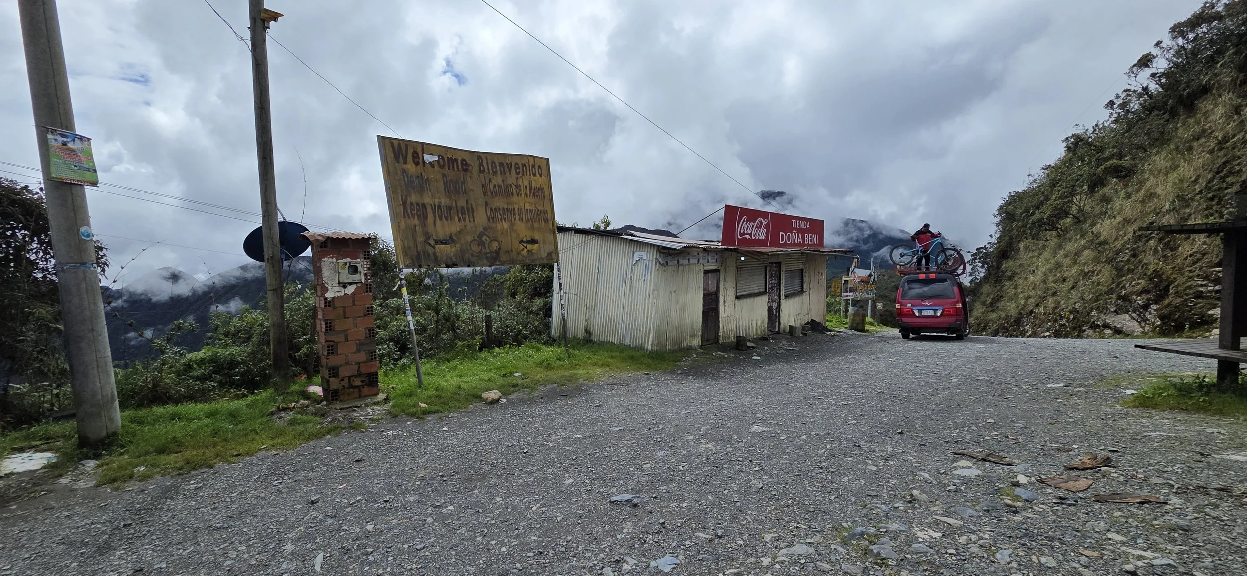
For the first hour, you'll whisk down well-paved, winding roads, possibly through clouds, tiny local villages and absolutely amazing landscapes. Transparently, you might even encounter a few scary dogs that chase you. I strongly recommend taking photos whenever possible because cloud cover can occur at any given moment. You reach the official start of Death Road at this sign, which is where you'll want to change into lighter clothing. At this point, you should also explain the most important aspects of your ride to your guide—for example, whether you want to go fast, how often you want to stop for photos, etc.—and they will customize the ride. An emergency van will trail far behind you at all times. Get a few photos and videos of the van on the narrow roads before the road widens later on.
Within only 5 minutes of the ride, you'll reach the first main photo spot: a turquoise structure with a view of what's in store. You will likely see a few other groups on the road, but it was much emptier than expected-- which I obviously loved. That being said, professional mountain bikers from around the world will occasionally sprint down the hill past you at dangerous speeds.
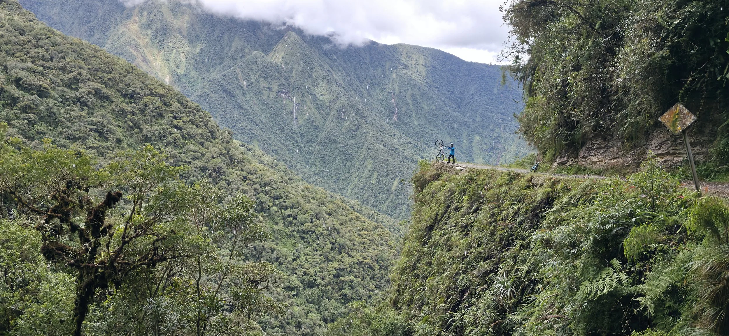
The iconic photo "Instagram" spot is on the road's most dramatic section, roughly an hour after the turquoise structure near the San Rafael Waterfall, but I might be a little off on the time. I was fortunate enough to have this spot to myself for the first 30 minutes, but a line of ~10 people was waiting by the time I left. I should have mentioned this earlier: ask your guide to start the tour earlier than normal to stay ahead of any potential bike traffic. To get this photo, you'll need the guide to take it with your camera unless you're with others. Even after giving this tour so many times, they are terrible at photography so you'll need to provide exact instructions. Holding the camera vertically is an even better option because it shows the steepness, but horizontal fits better into my blog.
I asked the emergency van driver if he could drive ahead so I could video the madness. Believe it or not, this section of the road wasn't even close to the most dangerous one he wouldn't allow for. Imagine 30 years ago when this was the main route through the mountains and trucks were coming from the opposite direction!
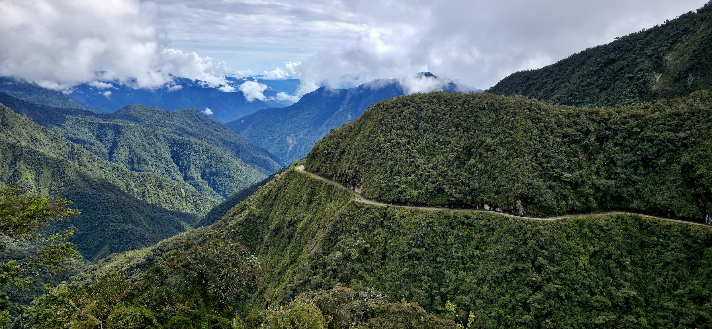
The road opens up during the last hour of the journey, allowing faster travel through the villages and subtropical climate if you choose to do so. Overall, it was one of my favorite extreme adventure experiences on any trip and I would do it again in a heart beat. Although I was nervous at a few points, the road wasn't nearly as dangerous as I expected. At the end of the ride for an extra cost, you have an opportunity to visit La Senda Verde, an animal sanctuary situated near the village of Yolosa. The sanctuary rescues animals from trafficking and was surprisingly a worthwhile stop.
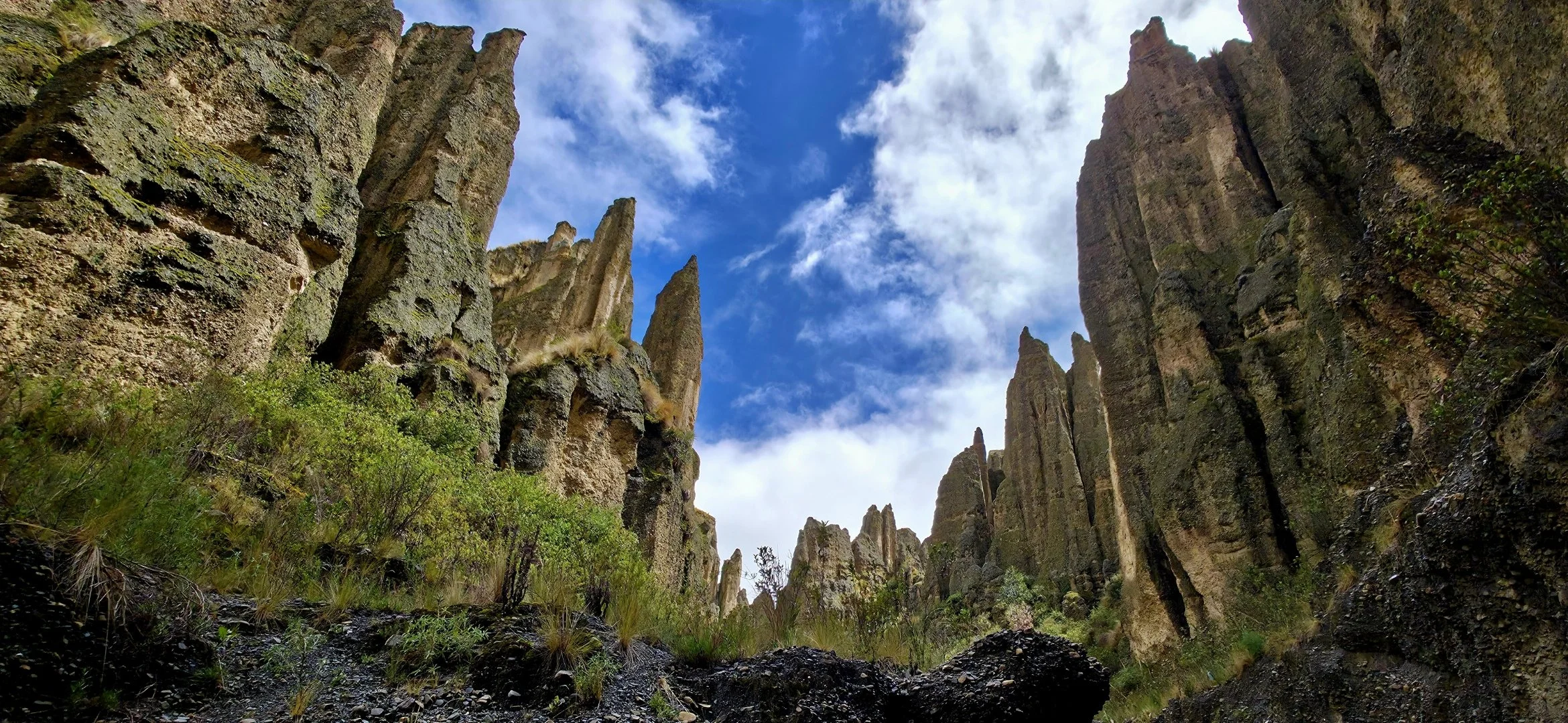
You can accomplish the last two activities, Valle de la Animas and the Teleférico, on the same day if you start the hike at 6am and have the energy to conquer the cable cars in the afternoon. Valle de las Animas is a spectacular geological formation located approximately 30 minutes from Zona Sur. Do not confuse Animas with Valle de la Luna, the latter offers a similar activity but is a tourist trap and not nearly as majestic. Valle de la Animas is known for its thousands of needle-like rock spires that reach heights of up to 200 meters. It offers a dramatic, otherworldly landscape shaped by millions of years of wind and water erosion. The only issue with Valle de la Animas is that the "unofficial" entrance is in an obscure area that is difficult for Ubers to find. Additionally, few Ubers will pick you up after the hike so you'll need to walk to the nearby village to call an Uber or find a taxi. The entrance is a lonely, gravelly road that almost looks like a construction site and you might even see a cow or two nearby. There aren't many other hikers so if you don't see anyone, it doesn't mean you're not in the right place.
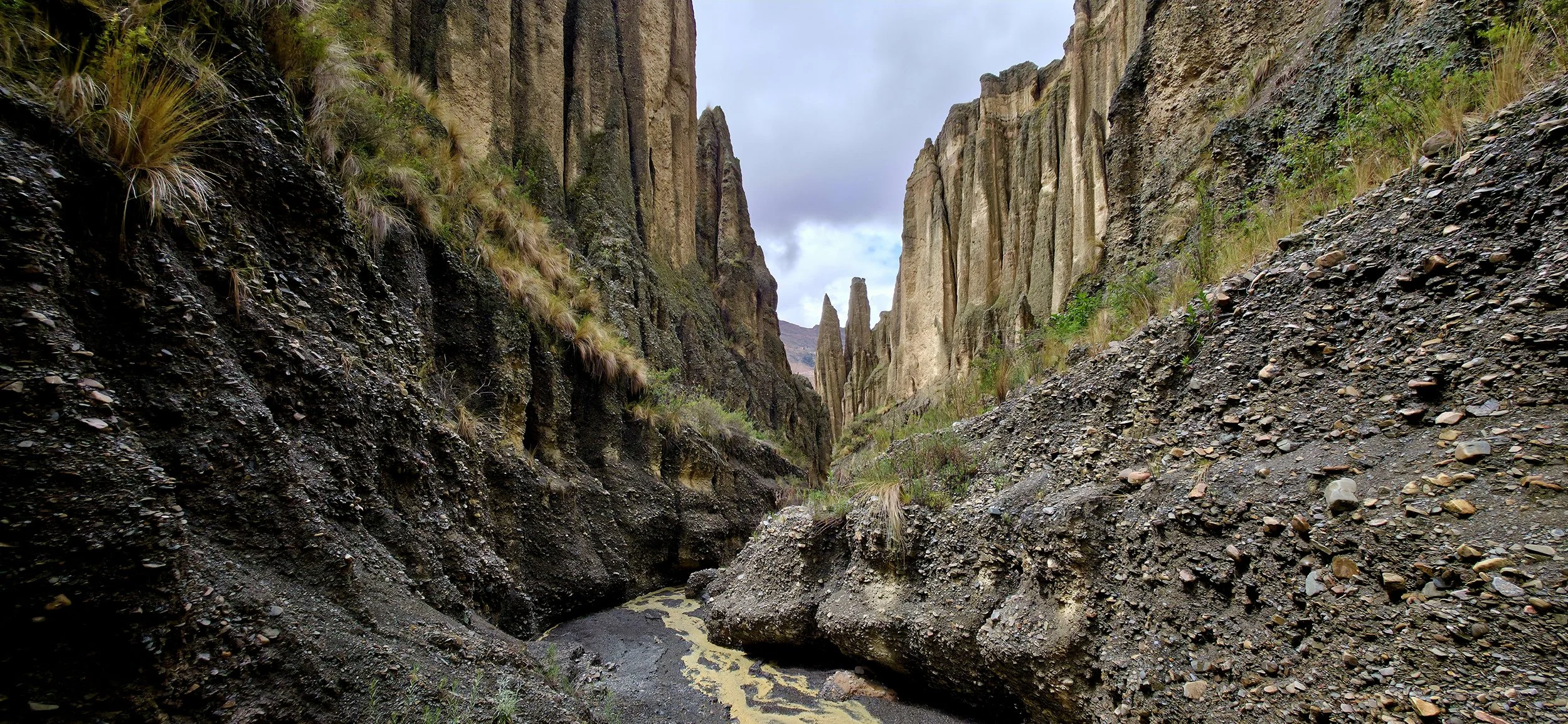
There is no entrance fee and it's open 24-7. The hike typically takes between 2 and 5 hours, but you'll see plenty even if you only last 2 hours. Because the area is at a very high altitude, even shorter distances can be physically demanding. In my opinion, the first 30 minutes of the hike were the most scenic, although others might disagree. Within the first 15 minutes, the trail narrows, requiring you to squeeze between rock walls, duck under rocky overhangs and navigate slippery rocks. You will likely get dirty so dress accordingly with durable hiking boots. You may see Andean foxes, viscachas, llamas, alpacas, and donkeys throughout the valley, but no dangerous predators exist. Both of these photos were taken within the first 30 minutes of the hike looking up hill. However, this is one of those hikes where you'll always want to keep your head on a swivel since great photos exist at every angle.
The Teleferico is the world's highest and largest urban cable car system, offering breathtaking views of the city and surrounding Andes. They are super convenient, safe and popular with locals due to user-friendly systems, which makes them easier to navigate than US metros. They run every 12 seconds with ride times lasting 15–17 minutes depending on your destination. Each ride costs approximately $.40. Operating hours typically range from 6am to 10pm and may vary between weekdays and weekends depending on the line. The Teleferico is so popular that it's difficult to get an empty car, but I got lucky a few times and took advantage of the photo opportunities. The locals are usually very quiet and keep to themselves, but they become vocal if you stand up during the ride, as it's strictly prohibited.
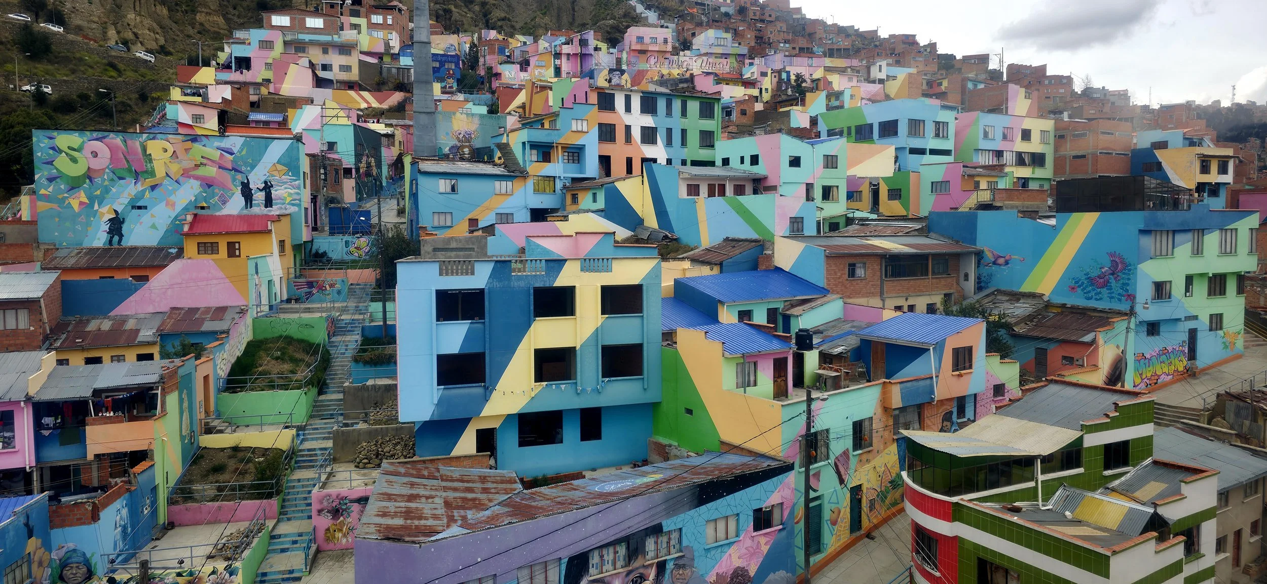
I must have spent an entire day riding every Teleferico line, stopping in random local neighborhoods, and meeting a few fascinating people along the way. In my opinion, the most scenic line by far is the Red Line which offers a unique perspective of the city, passing over the large General Cemetery, the colorful Chualluma neighborhood, and climbing up to El Alto. The views from El Alto are spectacular, especially if you are there on a Thursday or Sunday when the large market is in full swing. I would say that the Yellow and Green are tied for second place. Locals often cite the Yellow Line as the most scenic; it offers incredible views of the city, mountains, and the upper cliffs. The Green Line runs through the lower, more affluent neighborhoods and along the city's southern part, providing excellent views of the surrounding canyon walls and vegetation. Both the video and photo were taken a few minutes after leaving the top of the Red Line looking back at the Chualluma neighborhood.
That said, this concludes my Bolivian blog, however, I left several more photos below since there were so many to choose from. As a reminder, my blog covers only a small portion of Bolivia so spend a few days searching for what's out there and then decide on your top destinations. One thing is for sure: you'll likely be one of the few tourists in most of these areas—a rarity in South America (at least for now).